place

Sullivans Dam

Lakes of OtagoLeith ValleyOtago geography stubsReservoirs in New Zealand

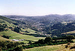
Sullivans Dam (often incorrectly but grammatically referred to as Sullivan's Dam) is a reservoir in a forested area 10 kilometres (6.2 mi) to the north of the centre of Dunedin, New Zealand. The dam is located to the east of Mount Cargill, close to the Dunedin Northern Motorway in the upper Leith Valley, some 500 metres southeast of the Leith Saddle. It was proposed in 1909 by City Councillor Archibald J. Sullivan (1869–1932), after whom it is named, in order to expand Dunedin's water supply. Work began in May 1913 and the reservoir was officially opened on 15 July 1916. The surrounding catchment area is today a popular site for walkers, with numerous bush walks around the reservoir. The reservoir was also stocked with trout shortly after its completion, and stocks of the fish are periodically replenished. As such, the reservoir provides popular sport for anglers.

Excerpt from the Wikipedia article Sullivans Dam (License: CC BY-SA 3.0, Authors).

Sullivans Dam
Sullivans Dam, Dunedin

Geographical coordinates (GPS) Address Nearby Places
placeShow on map

Wikipedia: Sullivans DamContinue reading on Wikipedia

Geographical coordinates (GPS)

Latitude Longitude
N -45.806944444444 ° E 170.52361111111 °
placeShow on map

Address

Sullivans Dam

Sullivans Dam
9010 Dunedin
Otago, New Zealand
mapOpen on Google Maps

Share experience

Nearby Places

Leith Saddle
Leith Saddle

Leith Saddle is a saddle between the sources of the Water of Leith and the Waitati River, approximately halfway between Dunedin's northern suburb of Pine Hill and the outlying settlement of Waitati. The saddle is a strategic point where the Dunedin Northern Motorway, part of State Highway 1 traverses a fragile alpine forest. Proposed road works to straighten a dangerous corner here conflict with conservation values. Water supply pipelines, and popular tramping and cycling routes also converge at the saddle. The Water of Leith's source is 100 metres to the south of Leith Saddle, at a height of 380 metres above sea level.The Leith Saddle Track is a 3.5 hour climb through native cloud forest to Swampy Spur and Swampy Summit with links to other walkways in the Silverpeaks and Dunedin's hills.The Dunedin Northern Motorway has an at-grade intersection at the Leith Saddle summit with Leith Valley Road and Waitati Valley Road. Both have low motor vehicle volumes and have metalled surfaces, making them attractive to cyclists.Transit New Zealand signalled a long term intention in 2004 to realign SH1 in the vicinity of Leith Saddle; construction would require removal of some old-growth forest. The forest here features a species of Libocedrus, variously called Pahautea, Kaikawaka or New Zealand cedar, Libocedrus bidwillii, which is unusual in this region of New Zealand.Transit New Zealand stated in 2004 that Leith Saddle has 250% more accidents than average for the New Zealand state highway network and that the accident rate increased by 50% in the ten years to 2004. They said realignment here would reduce traffic delays, fuel use, crashes, and emissions of carbon dioxide and carbon monoxide.A contour pipeline running southbound over the saddle from several tributaries of the Waitati River feeds two of Dunedin's water supply reservoirs in Leith Valley: Ross Creek Reservoir and Sullivans Dam. Treated, fluoridated water is transmitted northwards from Dunedin's municipal water system via a new pipeline to the rural settlements of Waitati, Warrington and Seacliff.

Bethune's Gully
Bethune's Gully

Bethune's Gully is notable geological feature of northern Dunedin, in the South Island of New Zealand. It is located close to the suburb of Normanby towards the northern end of North East Valley. It preserves a number of acres of very old-growth forest and a large stand of exotic Douglas fir, and is an ecosystem directly below the cloud forest on the upper slopes of Mount Cargill. The gully was formed by the upper reaches of Lindsay Creek, a tributary of the Water of Leith which flows along North East Valley. The gully is surrounded by an 86-hectare (210-acre) reserve and recreational area at the start of walking and trail-biking tracks which lead up the slopes of Mount Cargill, 2.5 kilometres (1.6 mi) to the north. The most notable of these is a 2-hour round trip walk which leads to the Cargill's summit, a rise of 580 metres (1,900 ft), which was opened in 1981.In 1996 Bethune's Gully was the venue for the New Zealand national mountain-biking championships. Biking tracks were extended after the championships and were opened to the public in 2003. Nearby Forrester Park, on Norwood Street, is home to the city's main BMX circuit.The reserve was named for David Bethune, who took over the property in 1878, setting up a sawmill and brick kiln. The property fell into disuse after it was sold by Bethune, only to be redeveloped by J. B. Thompson immediately after World War I and leased to the Dunedin City Council. It became city property after Thompson's death in 1955.The Gully is reached by Cluny Street, a short paved road off Normanby's Norwood Street, beyond which Norwood Street passes through a narrow cutting before emerging in open countryside.