Oregon Trail (Ada County, Idaho segment)
.jpg)
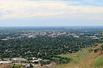
The Oregon Trail (Ada County, Idaho segment) near Boise, Idaho, includes approximately eight miles of the Oregon Trail as it entered the Boise Valley. The segment was added to the National Register of Historic Places (NRHP) in 1972. At the time of the NRHP nomination, wagon tracks from the Oregon Trail could be identified almost continuously from the northwest and northeast quadrants of Section 36, Range 2 East, Township 2 North through the northwest and northeast quadrants of both Section 31, Range 3 East, Township 2 North and Section 24, Range 3 East, Township 1 North. In places along the segment the wagon tracks were eight tracks wide. The length of the segment is roughly from 43.56055556°N 116.15527778°W / 43.56055556; -116.15527778 to 43.5143915°N 116.1526384°W / 43.5143915; -116.1526384.The Oregon Trail Reserve is a 77-acre site managed by Boise Parks and Recreation, and the area includes part of the Oregon Trail segment designated by the NRHP in 1972. Nearby is the Oregon Trail Recreation Area, another part of the NRHP segment managed by Boise Parks and Recreation.Although the Oregon Trail followed the segment identified in the NRHP listing, it then continued along the route of what is now Boise Avenue. The Capitol Boulevard Memorial Bridge, also known as the Oregon Trail Memorial Bridge, is located where the Oregon Trail crossed the Boise River by ferry and proceeded through Boise City west toward Caldwell. A series of 21 obelisks now mark the route of the Oregon Trail through Boise.
Excerpt from the Wikipedia article Oregon Trail (Ada County, Idaho segment) (License: CC BY-SA 3.0, Authors, Images).Oregon Trail (Ada County, Idaho segment)
South Pinerest Way, Boise
Geographical coordinates (GPS) Address Nearby Places Show on map
 Continue reading on Wikipedia
 Geographical coordinates (GPS)
| Latitude | Longitude |
|---|---|
| N 43.5625 ° | E -116.15527777778 ° |
Address
South Pinerest Way 4388
83716 Boise
Idaho, United States
Open on Google Maps