High Orchard

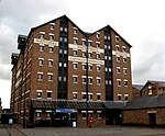
High Orchard was an industrial area of the city of Gloucester in England that was developed in the 19th century on the former orchard of the Priory of Llanthony Secunda (1136). The area was closely associated with Gloucester Docks immediately to the north, and served by the Gloucester and Sharpness Canal and railway transport. It was the site of Fielding & Platt's Atlas Works and a number of other significant local employers. It was centred on High Orchard Street which ran between Llanthony Road to the north and Baker Street to the south. To the west was Baker's Quay and to the east Southgate Street. Immediately south of Baker Street was the terminus of the High Orchard branch railway line. Most of the area is now the site of the Gloucester Quays shopping centre and associated buildings, with some original buildings surviving as part of the shopping centre and along the canal side.
Excerpt from the Wikipedia article High Orchard (License: CC BY-SA 3.0, Authors, Images).High Orchard
Saint Ann Way, Gloucester Linden
Geographical coordinates (GPS) Address Nearby Places Show on map
Geographical coordinates (GPS)
| Latitude | Longitude |
|---|---|
| N 51.858768 ° | E -2.256072 ° |
Address
Saint Ann Way
GL2 5GQ Gloucester, Linden
England, United Kingdom
Open on Google Maps


