place

Long Mynd

Church StrettonGeology of ShropshireHills of ShropshireMarilyns of EnglandMoorlands of England
National Trust properties in ShropshirePages with Welsh IPASites of Special Scientific Interest in ShropshireTourist attractions in Shropshire
Shropshire Long Mynd

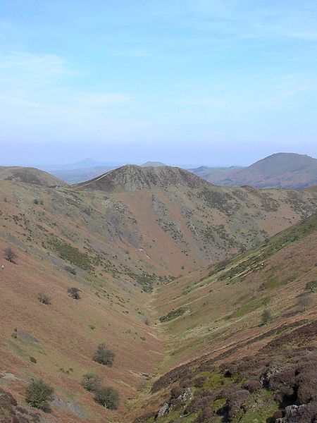
The Long Mynd (Welsh: Cefn Hirfynydd) is a heath and moorland plateau that forms part of the Shropshire Hills in Shropshire, England. The high ground, which is common land and designated as an Area of Outstanding Natural Beauty, lies between the Stiperstones range to the west and the Stretton Hills and Wenlock Edge to the east. Much of it is owned by the National Trust, and is managed by the Longmynd Commoners.The Long Mynd is approximately 7 miles (11 km) long by 3 miles (5 km) wide, and is broadly characterised by steep valleys on its eastern flanks, and a long slope to the western side rising in a steep escarpment. In its vicinity are the principal settlements of Church Stretton, Little Stretton and All Stretton, Pulverbatch, Smethcott, Woolstaston, Asterton, Myndtown, Wentnor and Ratlinghope. The highest point on the Long Mynd is Pole Bank (1,693 ft, 516 m); this and the adjacent hill of Caer Caradoc (1,506 ft, 459 m) are classed as Marilyns.

Excerpt from the Wikipedia article Long Mynd (License: CC BY-SA 3.0, Authors, Images).

Long Mynd
Lightspout Hollow,

Geographical coordinates (GPS) Address Nearby Places
placeShow on map

Wikipedia: Long MyndContinue reading on Wikipedia

Geographical coordinates (GPS)

Latitude Longitude
N 52.54775 ° E -2.8388944444444 °
placeShow on map

Address

Lightspout Hollow

Lightspout Hollow
SY6 6JG
England, United Kingdom
mapOpen on Google Maps

Shropshire Long Mynd
Share experience

Nearby Places

Church Pulverbatch
Church Pulverbatch

Church Pulverbatch is a small village and civil parish in central Shropshire, England. The population of the parish was 344 at the time of the 2001 census, increasing to 361 at the 2011 Census.It is located near Habberley and Picklescott. The nearest towns are Shrewsbury and Church Stretton; both are approximately 8 miles by road. Also within the parish is the village of Pulverbatch, which is situated on the Shrewsbury-Longden-Bridges road and has a public house, called the White Horse. The villages of Church Pulverbatch (also known as Churton) and Pulverbatch are less than half a mile apart. The hamlet of Wrentnall is situated to the north of Pulverbatch, also within the parish. The current Lord of Wrentnall, and Lord of Great Lyth, is also the Baron of Pulverbatch (Farrow, M. W. MA (Cantab), 7 April 2003, Lordships of Wrentnall and Pulverbatch). The Church of England parish church of St Edith, built of mauve rubblestone with Grinshill stone dressings, has an ornate west tower of 1773, but most of the present building, the nave and chancel, was restored in 1852-53 and a north aisle added by Shrewsbury architect Edward Haycock. Inside is a plain wooden west gallery and box pews, besides a framed Roll of Honour to parish men who served in World War I, and electric lighting that was fitted in memory of five men of the parish who died serving in World War II. The churchyard contains a Commonwealth war grave of a Canadian airman of World War II.On a hill to the south of Pulverbatch are the earthwork remains of Castle Pulverbatch, a medieval motte-and-bailey castle.