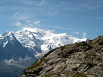
Rocher de la Tournette

The Rocher de la Tournette (or, simply, 'La Tournette') is a prominent rocky point on the icy summit ridge of Mont Blanc between the Petite Bosse and the summit. The highest point lies at 4,677 metres (15,344 ft) above sea level, and can be most easily reached on an ascent of Mont Blanc via the Goûter Route. Whilst not sufficiently isolated from other summits to be regarded by the UIAA as one of the 82 primary 4000 metre summits of the Alps, the organisation does nevertheless include Rocher de la Tournette on its 'Enlarged list of lesser summits'. This list defines a further 46 such points of secondary mountaineering or morphological interest, of which the Rocher de la Tournette is the highest.The shoulder of this rocky subsidiary summit offers a remote mountaineering route from the Quintino Sella Hut. Known as the Tournette Spur (fr: l’éperon de la Tournette), it enables the final 'Bosses Ridge' section of the Goûter Route to be reached from the Italian side of Mont Blanc. This infrequently climbed route is nowadays graded AD on the adjectival climbing scale and was first climbed on 2 July 1872 by T Kennedy, J Carrel and J Fischer. The first winter ascent of the Tournette Spur was made by the three Sella brothers and their guides, including Emile Rey on 5 January 1888.: 58
Excerpt from the Wikipedia article Rocher de la Tournette (License: CC BY-SA 3.0, Authors, Images).Rocher de la Tournette
Les Bosses, Bonneville
Geographical coordinates (GPS) Address Nearby Places Show on map
Geographical coordinates (GPS)
| Latitude | Longitude |
|---|---|
| N 45.832777777778 ° | E 6.8594444444444 ° |
Address
Les Bosses
Les Bosses
74400 Bonneville
Auvergne-Rhône-Alpes, France
Open on Google Maps


