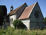
Spernall

Spernall is a remote village 4 miles (6.4 km) north of Alcester in the parish of Oldberrow, Morton Bagot, and Spernall, in the Stratford-on-Avon District of Warwickshire, England. In the 2001 Census it had a population of 153. It is situated on the banks of the small River Arrow, the name meaning Spera's border. Early forms of the name are Spernore. and Spernoure in the 1327 Subsidy Roll. The village consists only of the church and rectory and a few scattered farms and cottages. At some time between 1195 and 1361 the parish was largely depopulated by pestilence, so that many of the villein tenements, which had hitherto accounted for almost the whole population, came into the hands of freemen. This may well refer to the Black Death; the priest at Spernall, Nicholas atte Yate, died in 1349 and there was another institution in 1351. In the 17th century the population seems to have mainly consisted of substantial farmers, for in 1625 it is described as a place with 'few or no poor at all in it and many wealthy inhabitants', and the Hearth Tax returns (1662–74) show the high average of about 2.5 hearths per house. By 1696, there were only two yeomen with an estate of £10 a year or more.
Excerpt from the Wikipedia article Spernall (License: CC BY-SA 3.0, Authors, Images).Spernall
Spernal Lane, Stratford-on-Avon Spernall
Geographical coordinates (GPS) Address Nearby Places Show on map
Geographical coordinates (GPS)
| Latitude | Longitude |
|---|---|
| N 52.258 ° | E -1.875 ° |
Address
Spernal Lane
Spernal Lane
B80 7EX Stratford-on-Avon, Spernall
England, United Kingdom
Open on Google Maps


