place

Beer Hall Putsch

1920s coups d'état and coup attempts1920s in Munich1923 in Germany1924 in GermanyAdolf Hitler
Attempted coups in GermanyBeer Hall PutschConflicts in 1923EngvarB from January 2019Fascist revoltsMilitary operations involving GermanyNovember 1923 eventsRebellions in Germany
Bundesarchiv Bild 119 1486, Hitler Putsch, München, Marienplatz

The Beer Hall Putsch, also known as the Munich Putsch, was a failed coup d'état by Nazi Party (Nationalsozialistische Deutsche Arbeiterpartei or NSDAP) leader Adolf Hitler, Generalquartiermeister Erich Ludendorff and other Kampfbund leaders in Munich, Bavaria, on 8–9 November 1923, during the Weimar Republic. Approximately two thousand Nazis marched on the Feldherrnhalle, in the city centre, but were confronted by a police cordon, which resulted in the deaths of 16 Nazi Party members and four police officers.Hitler escaped immediate arrest and was spirited off to safety in the countryside. After two days, he was arrested and charged with treason.The putsch brought Hitler to the attention of the German nation for the first time and generated front-page headlines in newspapers around the world. His arrest was followed by a 24-day trial, which was widely publicised and gave him a platform to express his nationalist sentiments to the nation. Hitler was found guilty of treason and sentenced to five years in Landsberg Prison, where he dictated Mein Kampf to fellow prisoners Emil Maurice and Rudolf Hess. On 20 December 1924, having served only nine months, Hitler was released. Once released, Hitler redirected his focus towards obtaining power through legal means rather than by revolution or force, and accordingly changed his tactics, further developing Nazi propaganda.

Excerpt from the Wikipedia article Beer Hall Putsch (License: CC BY-SA 3.0, Authors, Images).

Beer Hall Putsch
Rosenheimer Straße, Munich Haidhausen - Süd (Au-Haidhausen)

Geographical coordinates (GPS) Address Nearby Places
placeShow on map

Wikipedia: Beer Hall PutschContinue reading on Wikipedia

Geographical coordinates (GPS)

Latitude Longitude
N 48.13 ° E 11.592 °
placeShow on map

Address

Rosenheimer Straße 15
81667 Munich, Haidhausen - Süd (Au-Haidhausen)
Bavaria, Germany
mapOpen on Google Maps

Bundesarchiv Bild 119 1486, Hitler Putsch, München, Marienplatz
Share experience

Nearby Places

Weißenburger Platz
Weißenburger Platz

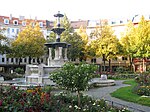
Weißenburger Platz is a square in Munich's Franzosenviertel (French Quarters) in the Haidhausen district. In the middle of the concentrically arranged square is the Glaspalast-Brunnen (glass palace fountain), designed by August von Voit in 1853. This was initially located in the Glaspalast in the Alter Botanischer Garten - hence the name. At the end of the 19th century the fountain was moved to Orleansplatz. When the Ostbahnhof (East Train Station) there was rebuilt, the Glaspalast-Brunnen had to make room and was moved to the nearby Weißenburger Platz. After dusk the fountains water feature is illuminated.Around the Glaspalast-Brunnen there are flowerbeds, which are planted several times a year. This circular green space is framed by a row of trees, under which benches are placed, and a ring-shaped street, which is partly a pedestrian zone. Five streets run towards Weißenburger Platz in the shape of a star: Metzstraße and Weißenburger Straße on both sides, and Lothringer Straße, where the municipal art gallery Lothringer13 is located near the square. In the buildings surrounding Weißenburger Platz there are various shops, restaurants, a pharmacy and a medical centre.Since 1976, Weißenburger Platz has hosted a Christmas market that has grown steadily over the years. Nowadays, the Weißenburger Platz is being overbuilt with over 60 stands for the Christmas market, which takes place annually from the end of November until Christmas.The name and design of the French Quarter have a historical background: When this quarter was created in 1872 after the German victory in the Franco-Prussian War (1870/1871), the planners decided to create squares and streets according to the French model. Therefore, the streets run towards the squares in a star shape. At the same time, they got their names from places where German armies won battles during the Franco-Prussian War. The Battle of Weissenburg gave its name to this square. Here the French army suffered a defeat in 1870. Today the small town in Alsace is no longer called Weißenburg but Wissembourg.