place

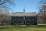
Lindenwold Castle

Buildings and structures in Montgomery County, PennsylvaniaCastles in the United States
Lindenwold, Castle, 701 Bethlehem Pike and Lindenwold Terrace, Ambler, Montgomery County, PA HABS PA,46 AMB,11A 5

Lindenwold Castle, also known as the Mattison Estate, is the former personal estate in Ambler, Pennsylvania, United States of asbestos magnate Richard Van Zeelust Mattison (1851–1935) of the Keasbey and Mattison Company. It was designed by Milton Bean and built in 1890.

Excerpt from the Wikipedia article Lindenwold Castle (License: CC BY-SA 3.0, Authors, Images).

Lindenwold Castle
South Bethlehem Pike, Upper Dublin Township

Geographical coordinates (GPS) Address Nearby Places
placeShow on map

Wikipedia: Lindenwold CastleContinue reading on Wikipedia

Geographical coordinates (GPS)

Latitude Longitude
N 40.150373 ° E -75.21264 °
placeShow on map

Address

South Bethlehem Pike 695
19002 Upper Dublin Township
Pennsylvania, United States
mapOpen on Google Maps

Lindenwold, Castle, 701 Bethlehem Pike and Lindenwold Terrace, Ambler, Montgomery County, PA HABS PA,46 AMB,11A 5
Share experience

Nearby Places

Gilkison's Corner, Pennsylvania

Gilkison's Corner was a small hamlet located in Montgomery County, Pennsylvania, in the United States. The community was in Upper Dublin Township, at the intersection of Butler Pike and Bethlehem Pike. The term is primarily archaic in usage, and the location does not appear on modern maps. Usage of the term appears to have declined towards the end of the 19th century, around the time of the establishment of the more heavily populated Borough of Ambler, whose eastern border is located along Bethlehem Pike. Located at the intersection of two heavily travelled early roads, Gilkison's Corner was the location of a Revolutionary War-era tavern. A large tannery was established just south of Gilkison's Corner in the 1850s, and Upper Dublin's post office was located in Gilkison's Corner until 1827. Bean's 1884 History of Montgomery County, Pennsylvania describes Gilkison's Corner as follows: Gilkison's Corner is situated at the intersection of the Spring House and Butler road turnpikes. It contains a store, six or seven houses and the extensive steam tannery of Alvin D. Foust, established some thirty years ago. It was at this place where Andrew Gilkison kept a tavern in the Revolution and for some years thereafter. The Upper Dublin post-office was located here before 1827, but has been removed half a mile distant ... At the present Gilkison's Corner, on the Bethlehem turnpike, Andrew Gilkison kept an inn from 1779 to 1786, and most probably later; hence the name of the place. This was on the store property now owned by David Dunnet. About a quarter of a mile above this place was a tavern formerly kept by Benjamin Daves. Paul Bower kept an inn in 1774, and Susanna Wright in 1779, which we are at present unable to locate, but very probably in this vicinity.

BoRit Asbestos
BoRit Asbestos

The BoRit Asbestos Superfund site is a 32-acre (13 ha) waste dump and reservoir in Ambler, Upper Dublin Township and Whitpain Township, Pennsylvania that was contaminated with 1.5 million cubic yards (1.1×10^6 m3) of asbestos containing material due to the waste disposal practices of the Keasbey and Mattison (K&M) Company and Turner and Newall from 1897 to 1962. The site is named BoRit after Bob Rittenhouse, one of the recent owners of the site. The site is divided into three parcels: an asbestos waste pile, a reservoir and a closed park. The asbestos waste pile was approximately 25 feet (7.6 m) and covered 2+1⁄2 acres (1.0 ha) of a 6-acre (2.4 ha) property. The reservoir was used for process water for manufacturing and is approximately 11 acres (4.5 ha) in size on a 15-acre (6.1 ha) lot. The berm of the reservoir was constructed from asbestos shingles, millboard and soil. The 11-acre (4.5 ha) Whitpain Wissahickon Park was used as an asbestos waste dump and then filled in and converted for usage as a park from 1973 to 1984 when it was closed and fenced-in due to asbestos contamination. The site also includes portions of Wissahickon Creek, Tannery Run Creek and Rose Valley Creek which run adjacent to the three parcels. The site is located in a densely populated borough with approximately 6,000 people living within 1⁄2 mile (0.80 km). It is the second largest asbestos dump site in the United States.The U.S. Environmental Protection Agency (EPA) conducted an emergency removal action in 2008 which included capping the asbestos waste pile with a geotextile material and 2 feet of clean material and stream bank stabilization of the three creeks. The EPA added the site to the Superfund National Priorities List in April 2009. The total cost of site clean-up was approximately $26 million. The site is currently being monitored on a quarterly basis and after significant weather events to ensure the integrity of the cap and stabilized stream banks. A five-year review will be completed by the EPA in 2022.