Smyrna Airport (Tennessee)

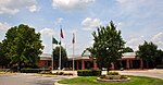
Smyrna Airport (IATA: MQY, ICAO: KMQY, FAA LID: MQY) is a public general aviation and military use airport located two nautical miles (4 km) north of the central business district of Smyrna, a town in Rutherford County, Tennessee, United States. It is owned by the Smyrna / Rutherford County Airport Authority. Smyrna Airport is the third largest airport in Tennessee and is the state's busiest general aviation airport. Prior to March 1971, the facility was an active military installation known as Sewart Air Force Base. This airport is included in the National Plan of Integrated Airport Systems for 2011–2015, which categorized it as a reliever airport for Nashville International Airport, which is located twelve nautical miles (22 km) to the north.
Excerpt from the Wikipedia article Smyrna Airport (Tennessee) (License: CC BY-SA 3.0, Authors, Images).Smyrna Airport (Tennessee)
Doug Warpoole Road,
Geographical coordinates (GPS) Address External links Nearby Places Show on map
 Continue reading on Wikipedia
 Geographical coordinates (GPS)
| Latitude | Longitude |
|---|---|
| N 36.008888888889 ° | E -86.52 ° |
Address
Smyrna Airport (Smyrna Airport (Tennessee))
Doug Warpoole Road 278
37167
Tennessee, United States
Open on Google Maps
External links