place

Bishopstone Cliffs

Local Nature Reserves in Kent
Sandstone cliff east of Bishopstone Glen geograph.org.uk 1470631

Bishopstone Cliffs is a 67.4-hectare (167-acre) Local Nature Reserve in Reculver on the eastern outskirts of Herne Bay, Kent. It is owned and managed by Canterbury City Council. It is part of Thanet Coast Site of Special Scientific Interest, and Thanet Coast and Sandwich Bay Ramsar site and Special Protection Area.This is a grassland site on the top of cliffs, and it has some rare insect species. Sand martins nest in holes in the cliffs, and other birds include skylarks, meadow pipits and corn buntings.There is public access to the site, most of which is within Reculver Country Park.

Excerpt from the Wikipedia article Bishopstone Cliffs (License: CC BY-SA 3.0, Authors, Images).

Bishopstone Cliffs
Oyster Bay Trail, Canterbury Bishopstone

Geographical coordinates (GPS) Address Nearby Places
placeShow on map

Wikipedia: Bishopstone CliffsContinue reading on Wikipedia

Geographical coordinates (GPS)

Latitude Longitude
N 51.376 ° E 1.177 °
placeShow on map

Address

Oyster Bay Trail

Oyster Bay Trail
CT6 6FR Canterbury, Bishopstone
England, United Kingdom
mapOpen on Google Maps

Sandstone cliff east of Bishopstone Glen geograph.org.uk 1470631
Share experience

Nearby Places

Reculver
Reculver

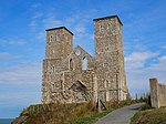
Reculver is a village and coastal resort about 3 miles (5 km) east of Herne Bay on the north coast of Kent in south-east England. It is in the ward of the same name, in the City of Canterbury district of Kent. Reculver once occupied a strategic location at the north-western end of the Wantsum Channel, a sea lane that separated the Isle of Thanet and the Kent mainland until the late Middle Ages. This led the Romans to build a small fort there at the time of their conquest of Britain in 43 AD, and, starting late in the 2nd century, they built a larger fort, or castrum, called Regulbium, which later became one of the chain of Saxon Shore forts. Following the withdrawal of the Western Roman Empire in ca. early C4th, the Brythons again took control of the lands until Anglo-Saxon invasions shortly afterward. By the 7th century Reculver had become a landed estate of the Anglo-Saxon kings of Kent. The site of the Roman fort was given over for the establishment of a monastery dedicated to St Mary in 669 AD, and King Eadberht II of Kent was buried there in the 760s. During the Middle Ages Reculver was a thriving township with a weekly market and a yearly fair, and it was a member of the Cinque Port of Sandwich. The settlement declined as the Wantsum Channel silted up, and coastal erosion claimed many buildings constructed on the soft sandy cliffs. The village was largely abandoned in the late 18th century, and most of the church was demolished in the early 19th century. Protecting the ruins and the rest of Reculver from erosion is an ongoing challenge. The 20th century saw a revival as local tourism developed and there are now two caravan parks. The census of 2001 recorded 135 people in the Reculver area, nearly a quarter of whom were in caravans at the time. The Reculver coastline is within a Site of Special Scientific Interest, a Special Protection Area and a Ramsar site, including most of Reculver Country Park, which itself includes much of Bishopstone Cliffs local nature reserve. While nationally scarce plants and insects are found there, the location is also important for migrating birds and is of significant geological interest.

St Mary's Church, Reculver

St Mary's Church, Reculver, was founded in the 7th century as either a minster or a monastery on the site of a Roman fort at Reculver, which was then at the north-eastern extremity of Kent in south-eastern England. In 669, the site of the fort was given for this purpose by King Ecgberht of Kent to a priest named Bassa, beginning a connection with Kentish kings that led to King Eadberht II of Kent being buried there in the 760s, and the church becoming very wealthy by the beginning of the 9th century. From the early 9th century to the 11th the church was treated as essentially a piece of property, with control passing between kings of Mercia, Wessex and England and the archbishops of Canterbury. Viking attacks may have extinguished the church's religious community in the 9th century, although an early 11th-century record indicates that the church was then in the hands of a dean accompanied by monks. By the time of Domesday Book, completed in 1086, St Mary's was serving as a parish church. The original building, which incorporated stone and tiles scavenged from the Roman fort, was a simple one consisting only of a nave and an apsidal chancel, with a small room, or porticus, built out from each of the church's northern and southern sides where the nave and chancel met. The church was much altered and expanded during the Middle Ages, including the addition of twin towers in the 12th century; the last addition, in the 15th century, was of north and south porches leading into the nave. This expansion coincided with a long period of prosperity for the settlement of Reculver: the settlement's decline led to the church's decay and, following unsuccessful attempts to prevent the erosion of the adjacent coastline, the building was almost completely demolished in 1809. The church's remains were preserved by the intervention of Trinity House in 1810, since the towers had long been important as a landmark for shipping: preservation was achieved through the first effective effort to protect the cliff on which the church then stood from further erosion. Some materials from the structure were incorporated into a replacement church, also dedicated to St Mary, built at Hillborough in the same parish. Much of the rest was used for the building of a new harbour wall at Margate, known as Margate Pier. Other, surviving remnants include fragments of a high cross of stone that once stood inside the church, and two stone columns from a triple arch between the nave and chancel: the columns formed part of the original church and were still in place when demolition began. The cross fragments and columns are now kept in Canterbury Cathedral, and are among features that have led to the church being described as an exemplar of Anglo-Saxon church architecture and sculpture.