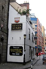
Redcliffe, Bristol
Redcliffe, also known as Redcliff, is a district of the English port city of Bristol, adjoining the city centre to the northwest. It is bounded by the loop of the Floating Harbour (including Bathurst Basin) to the west, north and east, together with the New Cut of the River Avon to the south. Most of Redcliffe lies within the city ward of Lawrence Hill, although the westernmost section, including the cliffs and hill from which the area takes its name, is in Cabot ward. Bristol Temple Meads station is located in Redcliffe. Redcliffe takes its name from the red sandstone cliffs which line the southern side of the Floating Harbour, behind Phoenix Wharf and Redcliffe Wharf. These cliffs are honey-combed with tunnels, known as the Redcliffe Caves, constructed both to extract sand for the local glass making industry and to act as store houses for goods. Part of the last remaining glass kiln in the area is now the Kiln Restaurant of the Ramada Bristol City Hotel in Redcliffe Way.The parish church of St. Mary Redcliffe is one of Bristol's best known churches, with the spire at a height of 292 ft (90m) making it the second tallest building in the city.
Excerpt from the Wikipedia article Redcliffe, Bristol (License: CC BY-SA 3.0, Authors).Redcliffe, Bristol
Alfred Place, Bristol Redcliffe
Geographical coordinates (GPS) Address Nearby Places Show on map
Geographical coordinates (GPS)
| Latitude | Longitude |
|---|---|
| N 51.4478 ° | E -2.5895 ° |
Address
Redcliffe Tunnel
Alfred Place
BS1 6ST Bristol, Redcliffe
England, United Kingdom
Open on Google Maps


