Rosetta, Tasmania
Localities of City of GlenorchySuburbs of HobartTowns in TasmaniaUse Australian English from August 2019
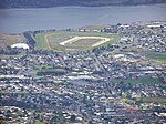
Rosetta is a residential locality in the local government area (LGA) of Glenorchy in the Hobart LGA region of Tasmania. The locality is about 3 kilometres (1.9 mi) north-west of the town of Glenorchy. The 2016 census recorded a population of 2731 for the state suburb of Rosetta. It is a suburb of Hobart. The suburb is situated between the suburbs of Berriedale and Montrose and is approximately 15 minutes drive from Hobart. There is a primary school and a high school in Rosetta. The Brooker Highway runs along the eastern border of the suburb, next to the Derwent River.
Excerpt from the Wikipedia article Rosetta, Tasmania (License: CC BY-SA 3.0, Authors).Rosetta, Tasmania
Marys Hope Road, Hobart Rosetta
Geographical coordinates (GPS) Address Nearby Places Show on map
 Continue reading on Wikipedia
 Geographical coordinates (GPS)
| Latitude | Longitude |
|---|---|
| N -42.823611111111 ° | E 147.25027777778 ° |
Address
Marys Hope Road
Marys Hope Road
7010 Hobart, Rosetta
Tasmania, Australia
Open on Google Maps