place

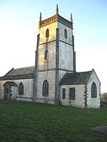
Church of the Holy Trinity, Binegar

Grade II* listed buildings in Mendip DistrictGrade II* listed churches in Somerset
Holy Trinity, Binegar (geograph 2584993)

The Anglican Church of the Holy Trinity, Binegar, Somerset, England is Norman but has been rebuilt and restored several times since. It is a Grade II* listed building.

Excerpt from the Wikipedia article Church of the Holy Trinity, Binegar (License: CC BY-SA 3.0, Authors, Images).

Church of the Holy Trinity, Binegar
Station Road, Mendip

Geographical coordinates (GPS) Address External links Nearby Places
placeShow on map

Wikipedia: Church of the Holy Trinity, BinegarContinue reading on Wikipedia

Geographical coordinates (GPS)

Latitude Longitude
N 51.243 ° E -2.5523 °
placeShow on map

Address

Holy Trinity Church

Station Road
BA3 4UH Mendip
England, United Kingdom
mapOpen on Google Maps

linkWikiData (Q17552254)
linkOpenStreetMap (863496791)

Holy Trinity, Binegar (geograph 2584993)
Share experience

Nearby Places

Emborough Quarries

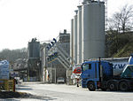
Emborough Quarries (grid reference ST623505) is a 1 hectare (2.5 acre) geological Site of Special Scientific Interest at Emborough in the Mendip Hills, Somerset, notified in 1971. The disused quarry has yielded a wide variety of remains of vertebrate fossils, amongst which the early reptiles are particularly well represented. Of special note is Kuehneosaurus latus which is one of the earliest-known flying vertebrates. During the Triassic period of geological time, some 230 million years ago, the limestones now exposed on Mendip formed upland areas upon which a number of large rivers rose. Solution cavities were soon created in the land surface and material from the surrounding area was swept into the newly formed cave systems. Remains of the creatures living in the upland areas during this time were swept into these deposits and have now been exhumed by recent quarrying activities. Fresh material is brought to the surface with every rock fall and Emborough Quarries are a nationally important source of fossil vertebrate remains for research and study.This former Mendip quarry site, probably owned by Emborough Stone Co., a branch of Roads Reconstruction, Ltd., where iron ore was once mined is now home to an assembly of contractor's plant (possibly of Richard Wood (Engineering) Ltd), cranes and machine tools. It is the location of Nettlebridge Viaduct, a seven-arch bridge that once carried the Somerset and Dorset Railway.The site was owned by Emborough Stone Co which was later bought by Roads Reconstruction Ltd. The rock quarried was carboniferous mountain limestone which was used for construction and railway ballast. There are 2 main quarries and several trial quarries. The site was previously used by the Emborough Brick Co for making clay bricks.

Masbury railway station

Masbury railway station was a small isolated station on the Somerset and Dorset Joint Railway's main line between Evercreech Junction and Bath. It was situated to the north of Shepton Mallet and near the summit of the line as it crossed the Mendip Hills. The station opened in 1874 and closed with the rest of the line under the Beeching Axe in March 1966. Maesbury Railway Cutting is a two hectare geological Site of Special Scientific Interest between East Horrington and Gurney Slade and a Geological Conservation Review site because it exposes approximately 135 metres of strata representing the middle and upper Lower Limestone Shales and the basal Black Rock Limestone. Both formations are of early Carboniferous (Courceyan) age. It lies close to the Iron Age hill fort Maesbury Castle. The station was never heavily used, and from 1938 it was reduced to a "halt" status. A feature of the station was a substantial stone-built stationmaster's house on the main northbound platform. The front of the house, which is still standing and in private hands, features a fanciful carving of Maesbury Castle as a medieval castle: in fact, Maesbury is an Iron Age fort nearby. There is about a half-mile of ramparts and views to Glastonbury Tor. The station is located mostly on private land but a public footpath crosses it. In May 2013 an online appeal was launched by the Somerset & Dorset Railway Heritage Trust to raise £500,000 by 30 September 2013 to purchase the station. The trust eventually raised only £80,000 by the deadline, and the site was sold to another party. The site is now in private hands so visitors are asked to respect the fact that it is a family home. Plans are in progress to restore the station to its original state, including rebuilding the signal box and renovating the platforms and waiting rooms.