place

Aust

Civil parishes in GloucestershireOpenDomesdayPopulated places on the River SevernUse British English from September 2013Villages in South Gloucestershire District
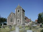
Aust church geograph.org.uk 110918

Aust is a small village in South Gloucestershire, England, about 10 miles (16 km) north of Bristol and about 28 miles (45 km) south west of Gloucester. It is located on the eastern side of the Severn estuary, close to the eastern end of the Severn Bridge which carries the M48 motorway. The village has a chapel, a church and a public house. There is a large area of farmland on the river bank, which is sometimes flooded due to the high tidal range of the Severn. Aust Cliff, above the Severn, is located about 0.5 miles (0.80 km) from the village. The civil parish of Aust includes the villages of Elberton and Littleton-upon-Severn.

Excerpt from the Wikipedia article Aust (License: CC BY-SA 3.0, Authors, Images).

Aust
Main Road, Bristol

Geographical coordinates (GPS) Address Nearby Places
placeShow on map

Wikipedia: AustContinue reading on Wikipedia

Geographical coordinates (GPS)

Latitude Longitude
N 51.59911 ° E -2.61788 °
placeShow on map

Address

Main Road
BS35 4AZ Bristol
England, United Kingdom
mapOpen on Google Maps

Aust church geograph.org.uk 110918
Share experience

Nearby Places

Littleton-upon-Severn

Littleton-upon-Severn is a village and former civil parish, now in the parish of Aust, in the South Gloucestershire district, in the ceremonial county of Gloucestershire, England, near the mouth of the River Severn and is located to the west of Thornbury. Historically it belonged to the Hundred of Langley and Swinehead. In 1931 the parish had a population of 179. On 1 April 1935 the parish was abolished and merged with Aust.A church was first mentioned as being in the village when the abbot of Malmesbury held a court leet here each year under a licence from king Edward the Martyr (975-979), and in the Domesday Book it was listed as being in the Langley hundred, and having a priest and thirty acres of pasture. In the twelfth century, the wooden church was replaced with a stone building, and the font and piscine are also twelfth century.The present parish church of St Mary's of Malmesbury is a Grade II* listed building, having been registered on 30 March 1960. It dates from the fourteenth century but was largely rebuilt in 1878. It is built out of rubble stone in the Decorated style, with a roof of fish-scale tiles. The plan consists of a nave, south porch and aisle, chancel, north vestry, and tower at the west end.The village contains a popular 17th century pub called The White Hart.Littleton Brick Pits are an artificial lagoon, once the site of clay extraction for brick making, where the Avon Wildlife Trust have reintroduced reedbeds close to the Severn Estuary as a feeding and resting place for migrating birds.