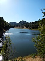
Cañada Garcia Creek
California river stubsRivers of Northern CaliforniaRivers of Santa Clara County, CaliforniaSanta Clara County, California geography stubs

Cañada Garcia Creek is a perennial stream in southwest Santa Clara County, California, United States. The headwaters rise on the southern flank of Portezuelo Gap near Manzanita Ridge in the eastern foothills of the Santa Cruz Mountains. From there, the creek flows southeastward, eventually merging with Llagas Creek.
Excerpt from the Wikipedia article Cañada Garcia Creek (License: CC BY-SA 3.0, Authors, Images).Cañada Garcia Creek
Uvas Road,
Geographical coordinates (GPS) Address Nearby Places Show on map
Geographical coordinates (GPS)
| Latitude | Longitude |
|---|---|
| N 37.124166666667 ° | E -121.73333333333 ° |
Address
Uvas Road 18862
95037
California, United States
Open on Google Maps


