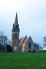
Tatenhill
Borough of East StaffordshireStaffordshire geography stubsUse British English from May 2015Villages in Staffordshire

Tatenhill is an ancient village and a civil parish located in a deep valley, between two hills, which gradually descend from the eastern border of Needwood Forest, 3.5 miles (5.6 km) west-southwest of Burton upon Trent, Staffordshire, England.
Excerpt from the Wikipedia article Tatenhill (License: CC BY-SA 3.0, Authors, Images).Tatenhill
Dark Lane, East Staffordshire Tatenhill
Geographical coordinates (GPS) Address Nearby Places Show on map
Geographical coordinates (GPS)
| Latitude | Longitude |
|---|---|
| N 52.795 ° | E -1.699 ° |
Address
Dark Lane
Dark Lane
DE13 9SD East Staffordshire, Tatenhill
England, United Kingdom
Open on Google Maps


