Astbury, Cheshire
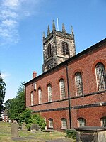
Astbury was one of the eight ancient parishes of the Macclesfield Hundred of Cheshire, England. It included two chapelries and ten townships. The chapelry of Congleton was an ancient borough and became a municipal borough in 1835. Under the Poor Law Amendment Act 1886 the townships and chapelries became civil parishes in their own right. Nine of the townships became part of Congleton Rural District in 1894. whereas Eaton became part of Macclesfield Rural District. At the same time, the Chapelry of Buglawton was made an Urban Sanitary District before being abolished in 1936. On its abolition 2,865 acres (11.59 km2) were transferred to Congleton, 32 acres (130,000 m2) to Eaton and 14 acres (57,000 m2) to North Rode.St. Mary's at Astbury is a large 12th-century church, rebuilt on a unique trapezoidal plan in the 13th and 14th centuries. There is a 14th-century effigy of a knight in the Lady Chapel, and another, possibly earlier, canopied tomb in the churchyard. A fragment of a Saxon cross is built into the exterior wall. Ada, fourth daughter of David, 9th Earl of Huntingdon (c1144-1219), is buried here. Chapelries: Buglawton CongletonTownships: Davenport Eaton Hulme Walfield Moreton cum Alcumlow Newbold Astbury Odd Rode Radnor Smallwood Somerford Somerford Booths
Excerpt from the Wikipedia article Astbury, Cheshire (License: CC BY-SA 3.0, Authors).Astbury, Cheshire
Puddle Bank Lane,
Geographical coordinates (GPS) Address Nearby Places Show on map
Geographical coordinates (GPS)
| Latitude | Longitude |
|---|---|
| N 53.14 ° | E -2.195 ° |
Address
Puddle Bank Lane
Puddle Bank Lane
CW12 3NW , Newbold Astbury
England, United Kingdom
Open on Google Maps


