place

Technical University of Kaiserslautern

1970 establishments in West GermanyTechnical University of KaiserslauternTechnical universities and colleges in GermanyUniversities and colleges established in 1970Universities and colleges in Rhineland-Palatinate
TUKL LOGO 4C
TUKL LOGO 4C

Technical University of Kaiserslautern (German: Technische Universität Kaiserslautern, also known as TU Kaiserslautern or TUK) was a public research university in Kaiserslautern, Germany. On January 1, 2023, the university was merged with the Landau campus of the University of Koblenz-Landau into the University of Kaiserslautern-Landau, or Rheinland-Pfälzische Technische Universität Kaiserslautern-Landau (RPTU) in German. There are numerous institutes around the university, including two Fraunhofer Institutes (IESE and ITWM), the Max Planck Institute for Software Systems (MPI SWS), the German Research Center for Artificial Intelligence (DFKI), the Institute for Composite Materials (IVW) and the Institute for Surface and Thin Film Analysis (IFOS), all of which cooperate closely with the university.TU Kaiserslautern was organized into 12 faculties. Approximately 14,869 students are enrolled at the moment. The TU Kaiserslautern is part of the Software-Cluster along with the Technische Universität Darmstadt, the Karlsruhe Institute of Technology and Saarland University. The Software-Cluster won the German government's Spitzencluster competition, the equivalence to the German Universities Excellence Initiative for clusters.

Excerpt from the Wikipedia article Technical University of Kaiserslautern (License: CC BY-SA 3.0, Authors, Images).

Technical University of Kaiserslautern
Gottlieb-Daimler-Straße, Kaiserslautern Lämmchesberg

Geographical coordinates (GPS) Address Nearby Places
placeShow on map

Wikipedia: Technical University of KaiserslauternContinue reading on Wikipedia

Geographical coordinates (GPS)

Latitude Longitude
N 49.423888888889 ° E 7.7530555555556 °
placeShow on map

Address

Gebäude 46

Gottlieb-Daimler-Straße 46
67663 Kaiserslautern, Lämmchesberg
Rhineland-Palatinate, Germany
mapOpen on Google Maps

TUKL LOGO 4C
TUKL LOGO 4C
Share experience

Nearby Places

Battle of Kaiserslautern (1794)

The Battle of Kaiserslautern (23 May 1794) saw an army from the Kingdom of Prussia and Electoral Saxony led by Wichard Joachim Heinrich von Möllendorf fall upon a single French Republican division under Jean-Jacques Ambert from the Army of the Moselle. The Prussians tried to surround their outnumbered adversaries but most of the French evaded capture. Nevertheless, Möllendorf's troops inflicted casualties on the French in the ratio of nine-to-one and occupied Kaiserslautern. While the Prussians won this triumph on an unimportant front, the French armies soon began winning decisive victories in Belgium and the Netherlands. The battle occurred during the War of the First Coalition, part of the French Revolutionary Wars. In 1794 Kaiserslautern was part of the Electoral Palatinate but today the city is located in the state of Rhineland-Palatinate in Germany about 67 kilometres (42 mi) west of Mannheim. In December 1793, the French drove the soldiers of Habsburg Austria and Prussia from French soil in the Second Battle of Wissembourg and took positions beyond the eastern frontier. That spring the Army of the Moselle sent heavy reinforcements to northeast France, leaving the Rhine front lightly defended by troops under Jean René Moreaux. Taking advantage of French weakness, the main Prussian assault was aimed at Ambert who could only try to save as many of his troops as possible. Also on 23 May an Austro-Prussian army attacked the Army of the Rhine under Claude Ignace François Michaud but was repulsed at the Battle of Schifferstadt. After losing Kaiserslautern, the two French armies withdrew to positions closer to the frontier. Having expended almost the only initiative they displayed in 1794, the Prussians allowed their offensive to sputter to a halt.

Humberg Tower
Humberg Tower

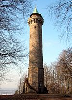
The Humberg Tower is an observation tower on the Humberg hill, 425 metres (1,400 feet) high, to the south of the city of Kaiserslautern in southwest Germany. The idea of building a tower on the Humberg (already in those days a favourite hill among the citizens of Kaiserslautern, for its view) was taken up in 1896. For this purpose, inhabitants of the city founded the Humberg Association, with the aim of financing the building of an observation tower. Among the founding members were the well-known sewing machine factory owner Pfaff, the mayor, Dr. Orth, distinguished businessmen, Pfeiffer and Karcher, and malt manufacturer, Gelbert. The tower was built to plans by the Munich architect, Ludwig Ritter von Stempel, who had already made a name for himself with some public buildings in the city. The Humberg Tower is a monumental construction of sandstone blocks, typical of the Wilhelminian period. Building began in the spring of 1899. The building material was quarried on the spot from the stone plateau of the Humberg. The tower was ceremonially opened on 2 September 1900. The tower is 35.77 metres (119 feet) high and its observation platform is 28.16 metres (93 feet) above the ground. The spiral staircase inside has 130 steps; in addition, there are a further 33 steps in the outside stairs at the base. In 1909, the existing Humberg Association was dissolved. The tower and the association's capital came into the possession of the city of Kaiserslautern. In 2001, the Humberg Tower Association of Kaiserslautern e.V. was founded with the aim of preserving the tower and its attractiveness as a goal for hikers.