Humberg (Kaiserslautern)
Mountains and hills of Rhineland-PalatinateMountains and hills of the Palatinate ForestRhineland-Palatinate geography stubs

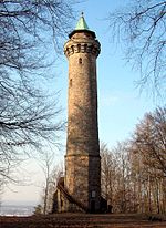
The Humberg is a mountain in the south of Kaiserslautern, Germany, that stands on the border of the Palatinate forest. With a height of 425 meters, it is the highest point in the area of Kaiserslautern. At its peak, the Humberg Tower (German: Humbergturm) provides a dramatic view of the area below.
Excerpt from the Wikipedia article Humberg (Kaiserslautern) (License: CC BY-SA 3.0, Authors, Images).Humberg (Kaiserslautern)
Hindenburgpfad, Kaiserslautern
Geographical coordinates (GPS) Address Nearby Places Show on map
Geographical coordinates (GPS)
| Latitude | Longitude |
|---|---|
| N 49.413332 ° | E 7.767591 ° |
Address
Hindenburgpfad
Hindenburgpfad
67663 Kaiserslautern
Rhineland-Palatinate, Germany
Open on Google Maps


