Nomansland Common

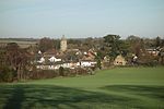
Nomansland Common (sometimes simply called No Man's Land) is an area of common land in Hertfordshire, England to the south of Harpenden and the south-west of Wheathampstead Geologically, the common is part of the Harpenden Dry Valley. In the last ice age a glacier dammed the river (which then flowed from Dunstable) south of Sandridge into St Albans Vale, creating a lake. When the dam melted and water drained away, it left the thin, stony soil still found on the common today. Nomansland has, throughout its history, been recognised for uniquely poor soil quality for agricultural purposes, although flint axe heads suggest that the common may have been cleared for grazing as long ago as 4000 BC. In World War II attempts were made to plant crops on the common, but the common yielded less than half of the produce per unit area as other arable land, despite heavy use of fertilisers. After the end of the war, the land was re-seeded as grass and returned to recreational use.
Excerpt from the Wikipedia article Nomansland Common (License: CC BY-SA 3.0, Authors, Images).Nomansland Common
Ferrers Lane, St Albans
Geographical coordinates (GPS) Address Nearby Places Show on map
Geographical coordinates (GPS)
| Latitude | Longitude |
|---|---|
| N 51.797628 ° | E -0.303583 ° |
Address
Ferrers Lane
AL4 8EQ St Albans
England, United Kingdom
Open on Google Maps


