place

Table Rock, Oregon

AC with 0 elementsJackson County, Oregon geography stubsUnincorporated communities in Jackson County, OregonUnincorporated communities in Oregon

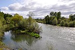
Table Rock is an unincorporated community in Jackson County, Oregon, United States. It lies near the Rogue River along Table Rock Road between White City and Sams Valley. The topographic features known as Upper and Lower Table Rock are slightly west of the community. Between 1853 and 1856, the Table Rock Indian Reservation lay between Upper Table Rock and Evans Creek, a Rogue River tributary to the west.A Table Rock post office operated in the vicinity of the two topographic landmarks from 1872 to 1895, until postal authorities changed the office name to Tablerock. Thomas Gianini was the first postmaster. Until the office permanently closed, it continued under the Tablerock name from 1895 through 1906 at varied locations in the valley near the two 1,000-foot (300 m) mesas.In 1949, the Southern Pacific opened a Table Rock station on its Siskiyou Line between Eugene and Black Butte, California. The station was about 3.5 miles (5.6 km) north of Central Point. The Pacific and Eastern Railway also had a Table Rock station near White City. Formerly known as the Medford and Crater Lake Railroad, it operated on 34 miles (55 km) of track between Medford and Butte Falls.

Excerpt from the Wikipedia article Table Rock, Oregon (License: CC BY-SA 3.0, Authors).

Table Rock, Oregon
Table Rock Road,

Geographical coordinates (GPS) Address Nearby Places
placeShow on map

Wikipedia: Table Rock, OregonContinue reading on Wikipedia

Geographical coordinates (GPS)

Latitude Longitude
N 42.451111111111 ° E -122.91277777778 °
placeShow on map

Address

Table Rock Road 10111
97502
Oregon, United States
mapOpen on Google Maps

Share experience

Nearby Places

Upper and Lower Table Rock

Upper Table Rock and Lower Table Rock are two prominent volcanic plateaus located just north of the Rogue River in Jackson County, Oregon, U.S. Created by an andesitic lava flow approximately seven million years ago and shaped by erosion, they now stand about 800 feet (240 m) above the surrounding Rogue Valley. The Table Rocks are jointly owned; The Nature Conservancy is responsible for 3,591 acres (1,453 ha), while the Bureau of Land Management is responsible for 1,280 acres (520 ha). Native Americans have inhabited the Table Rocks area for at least 15,000 years before European-American settlement. Starting in the mid-19th century during a gold rush, the settlers forced the Takelma tribe away from the Table Rocks and into reservations. The surrounding area was quickly developed. The Table Rock post office was established in 1872, an airstrip was built atop Lower Table Rock in 1948, and a very high frequency omni-directional range (VOR) aviation tower was constructed on Upper Table Rock in the 1960s. The Table Rocks were not protected until the 1970s. The rocks are home to over 70 species of animals and 340 species of plants, which includes over 200 species of wildflowers. Vernal pools atop the plateaus fill during the rainy season in winter and spring because the andesite is impermeable. The dwarf woolly meadowfoam, a species of wildflower, grows around these pools, and is endemic to the rocks. The pools are also one of only a few places where the federally threatened species of fairy shrimp, Branchinecta lynchi, can be found. To protect these and other threatened species, the Bureau of Land Management has listed the rocks as an Area of Critical Environmental Concern since 1984. The Table Rocks are one of the most popular hiking locations in the Rogue Valley, with over 45,000 visitors annually. Two trails, Lower Table Rock Trail and Upper Table Rock Trail, were cut across the plateaus' slopes in the early 1980s by the Youth Conservation Corps, Boy Scouts, and the Oregon Department of Forestry. This effort was coordinated by John Ifft, a forester for the Medford Office of the BLM. The plateaus are named for their relatively flat tops. Upper and Lower refer to their location along the Rogue River, not their height. Upper Table Rock, 2,091 feet (637 m) above sea level at its highest point, is located upstream, while Lower Table Rock is farther downstream, with an elevation of 2,049 feet (625 m).

Little Butte Creek
Little Butte Creek

Little Butte Creek is a 17-mile-long (27 km) tributary of the Rogue River in the U.S. state of Oregon. Its drainage basin consists of approximately 354 square miles (917 km2) of Jackson County and another 19 square miles (49 km2) of Klamath County. Its two forks, the North Fork and the South Fork, both begin high in the Cascade Range near Mount McLoughlin and Brown Mountain. They both flow generally west until they meet near Lake Creek. The main stem continues west, flowing through the communities of Brownsboro, Eagle Point, and White City, before finally emptying into the Rogue River about 3 miles (5 km) southwest of Eagle Point. Little Butte Creek's watershed was originally settled by the Takelma, and possibly the Shasta tribes of Native Americans. In the Rogue River Wars of the 1850s, most of the Native Americans were either killed or forced onto Indian reservations. Early settlers named Little Butte Creek and nearby Big Butte Creek after their proximity to Mount McLoughlin, which was known as Snowy Butte. In the late 19th century, the watershed was primarily used for agriculture and lumber production. The city of Eagle Point was incorporated in 1911, and remains the only incorporated town within the watershed's boundaries. Large amounts of water are diverted from Little Butte Creek for irrigation, water storage, and power generation. Canal systems deliver the water to nearby Howard Prairie Lake and the Klamath River watershed, Agate Lake, and the Rogue Valley. Despite being moderately polluted, the creek is one of the best salmon-producing tributaries of the Rogue River. Coho and Chinook salmon migrate upstream each year; however, several dams hinder their progress. A fish ladder was built in 2005 to help fish swim past a dam constructed in Eagle Point in the 1880s, but was destroyed by flooding just three months later. It was rebuilt in 2008. Restoration of a 1.3-mile (2.1 km) artificially straightened section of the creek in the Denman Wildlife Area was completed in 2011.