place

Lion Creek and Lower Raypits

Essex Wildlife Trust
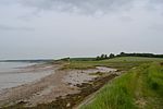
View From Garon Hide geograph.org.uk 1445511

Lion Creek and Lower Raypits is a 65.2-hectare (161-acre) nature reserve east of Canewdon in Essex. It is part of the Crouch and Roach Estuaries Site of Special Scientific Interest, and is owned and managed by the Essex Wildlife Trust.The former creek has been cut off from the Crouch Estuary by a seawall, and it has salt marsh plants such as golden samphire and sea-spurrey. There is a bird hide from which many species of sea birds can be seen. Lower Raypits can be accessed from Lion Creek by the seawall path. It has a variety of pasture, salt marsh and intertidal habitats, with nationally scarce plants such as beaked tasselweed, sea barley, grass vetchling and curved hard-grass. Invertebrates include Roesel's bush-cricket.There is access from the road between Canewdon and Wallasea Island.

Excerpt from the Wikipedia article Lion Creek and Lower Raypits (License: CC BY-SA 3.0, Authors, Images).

Lion Creek and Lower Raypits
Creeksea Ferry Road, Essex

Geographical coordinates (GPS) Address Nearby Places
placeShow on map

Wikipedia: Lion Creek and Lower RaypitsContinue reading on Wikipedia

Geographical coordinates (GPS)

Latitude Longitude
N 51.619 ° E 0.776 °
placeShow on map

Address

Creeksea Ferry Road

Creeksea Ferry Road
SS4 3PW Essex, Canewdon
England, United Kingdom
mapOpen on Google Maps

View From Garon Hide geograph.org.uk 1445511
Share experience

Nearby Places

Althorne railway station

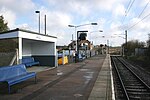
Althorne railway station is on the Crouch Valley Line in the East of England, serving the village of Althorne, Essex. It is 40 miles 27 chains (64.92 km) down the line from London Liverpool Street and is situated between North Fambridge to the west and Burnham-on-Crouch to the east. The station is managed by Greater Anglia who operate all services. The Engineer's Line Reference for line is WIS; the station's three-letter station code is ALN. The single platform, north of the running line, has an operational length for eight-coach trains. The line and station were opened on 1 June 1889 for goods and on 1 October 1889 for passenger services by the Great Eastern Railway. The facilities included a single platform with station buildings, a goods yard, and a 30-lever signal box south of the station. Two miles east of Althorne, Creeksea sidings (facing points in the "down" direction) received traffic to and from the Creeksea ferry from 1889 to 1947.Ownership passed to the London and North Eastern Railway following the Grouping of 1923, and then to the Eastern Region of British Railways upon nationalisation in 1948. When sectorisation was introduced, Althorne was served by Network SouthEast until the privatisation of British Railways. The goods yard closed on 19 December 1960, and the signal box on 21 January 1967. The level crossing to the east of the station was normally closed to road vehicles but was later converted to an automatic open crossing with lights. Electrification of the Wickford to Southminster line using 25 kV overhead line electrification (OLE) was completed on 12 May 1986.

Burnham-on-Crouch & District Museum

The Burnham-on-Crouch and District Museum, located in Burnham-on-Crouch, Essex, is a registered charity run by members of the Burnham History Society, aiming to reflect the history and development of the town and the local people. The museum is now situated on the waterfront at the end of Coronation Road, and occupies a former Tucker Brown boat builders premises originally constructed sometime around 1910. The museum moved to its current location in the late 1990s and with help of a national lottery grant extended the original boat builders adding a large lower gallery which houses the domestic life display with a mezzanine which houses a display on the agricultural history of the Dengie. Prior to moving to the current location the museum had started out in a small room off the high streetThe museum has a vast array of displays from the early Mesolithic inhabitants of Burnham-on-Crouch, the town during Roman occupation and the local Red hills ito the town's local history, with displays on domestic life, the local maritime history of the area with a full size boat built in Burnham on crouch, the agricultural history of the Dengie, the industrial history of the town with a displays dedicated to both the foundry and printers, and the areas social history. In 2015, the museum opened a new large display of Eocene fossils, including a comprehensive collection of Eocene shark teeth. The museum also contains an archive of local history documents, drawings, pictures and a reference library. The Burnham History Society hosts talks within the gallery of the museum on the third Monday of every month. The museum recently started an exciting new project restoring a large collection of Romano–British pottery, Iron Age pottery and Bronze Age pottery. The pottery is being restored in the main gallery to allow visitors so see the stages of restoration, and ask any questions they may have. The pottery was originally excavated by the Passmore Edwards museum immediately prior to the building of the Springfield Industrial Estate, it was given to the Burnham-on-Crouch & District Museum by the Passmore Edwards museum when they closed.

Burnham-on-Crouch railway station

Burnham-on-Crouch railway station is on the Crouch Valley Line in the East of England, serving the town of Burnham-on-Crouch, Essex. It is 43 miles 24 chains (69.68 km) down the line from London Liverpool Street and is situated between Althorne to the west and Southminster to the east. The Engineer's Line Reference for the line is WIS; the station's three-letter station code is BUU. The platform has an operational length for eight-coach trains. It is located near the Mangapps Railway Museum. The line and station were opened on 1 June 1889 for goods and on 1 October 1889 for passenger services by the Great Eastern Railway in 1889. The station had two platforms both with station buildings and connected by a footbridge. A 24-lever signal box was located on the north of the line to the west of the station; this was closed on 21 January 1967. There were sidings and a goods shed to the west of the station. The line and station were passed to the London and North Eastern Railway following the Grouping of 1923. It then passed to the Eastern Region of British Railways upon nationalisation in 1948. The north platform was closed by 1969. When sectorisation was introduced, Burnham-on-Crouch was served by Network SouthEast until the privatisation of British Rail. The line was electrified using 25 kV overhead line electrification (OLE) on 12 May 1986. Today the station is managed by Greater Anglia, which also operates all trains serving it.