place

Watkins Glen International

ARCA Menards Series tracksBuildings and structures in Schuyler County, New YorkChamp Car circuitsFormula One circuitsIMSA GT Championship circuits
IndyCar Series tracksInternational Race of Champions tracksMotorsport venues in New York (state)NASCAR races at Watkins Glen InternationalNASCAR tracksRoad courses in the United StatesSports venues on the National Register of Historic Places in New York (state)Tourist attractions in Schuyler County, New YorkUnited States Grand PrixWorld Sportscar Championship
Watkins Glen International Track Map

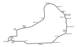
Watkins Glen International, nicknamed "The Glen", is an automobile race track located in the town of Dix just southwest of the village of Watkins Glen, New York, at the southern tip of Seneca Lake. It was long known around the world as the home of the Formula One United States Grand Prix, which it hosted for twenty consecutive years (1961–1980). In addition, the site has also been home to road racing of nearly every class, including the World Sportscar Championship, Trans-Am, Can-Am, NASCAR Cup Series, the International Motor Sports Association and the IndyCar Series. The facility is currently owned by NASCAR. The course was opened in 1956 to host auto races previously held on public roads in and around the village. The circuit's current layout has more or less been the same since 1971, with minor modifications after the fatal crashes of François Cevert in 1973 and J.D. McDuffie in 1991. The site has also hosted music concerts: the 1973 Summer Jam, featuring The Allman Brothers Band, the Grateful Dead and The Band and was attended by 600,000 fans; and two Phish festivals: Super Ball IX in 2011 and Magnaball in 2015.

Excerpt from the Wikipedia article Watkins Glen International (License: CC BY-SA 3.0, Authors, Images).

Watkins Glen International
Bronson Hill Road,

Geographical coordinates (GPS) Address External links Nearby Places
placeShow on map

Wikipedia: Watkins Glen InternationalContinue reading on Wikipedia

Geographical coordinates (GPS)

Latitude Longitude
N 42.336944444444 ° E -76.927222222222 °
placeShow on map

Address

Watkins Glen International

Bronson Hill Road
14891
New York, United States
mapOpen on Google Maps

linkWikiData (Q171449)
linkOpenStreetMap (702671615)

Watkins Glen International Track Map
Share experience

Nearby Places

Watkins Glen State Park

Watkins Glen State Park is in the village of Watkins Glen, south of Seneca Lake in Schuyler County in New York's Finger Lakes region. The park's lower part is near the village, while the upper part is open woodland. It was opened to the public in 1863 and was privately run as a tourist resort until 1906, when it was purchased by New York State. Initially known as Watkins Glen State Reservation, the park was first managed by the American Scenic and Historic Preservation Society before being turned over to full state control in 1911. Since 1924, it has been managed by the Finger Lakes Region of the New York State Office of Parks, Recreation and Historic Preservation. The centerpiece of the 778-acre (3.15 km2) park is a 400-foot-deep (120 m) narrow gorge cut through rock by Glen Creek, a stream that was left hanging when glaciers of the Ice age deepened the Seneca valley, increasing the tributary stream gradient to create rapids and waterfalls wherever there were layers of hard rock. The area's rocks are sedimentary of Devonian age, part of a dissected plateau that was uplifted with little faulting or distortion. They consist mostly of soft shales, with some layers of harder sandstone and limestone. The park features three trails, open from mid-May to early November, by which one can climb or descend the gorge. The Southern Rim and Indian Trails run along the gorge's wooded rim, while the Gorge Trail is closest to the stream and runs over, under and along the park's 19 waterfalls by way of stone bridges and more than 800 stone steps. The trails connect to the Finger Lakes Trail, an 800-mile (1,300 km) system of trails within New York state.