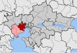
Macedonia ( (listen); Greek: Μακεδονία, romanized: Makedonía [maceðoˈni.a] (listen)) is a geographic and former administrative region of Greece, in the southern Balkans. Macedonia is the largest and second-most-populous Greek geographic region, with a population of 2.36 million in 2020. It is highly mountainous, with most major urban centres such as Thessaloniki and Kavala being concentrated on its southern coastline. Together with Thrace, and sometimes also Thessaly and Epirus, it is part of Northern Greece. Greek Macedonia encompasses entirely the southern part of the wider region of Macedonia, making up 51% of the total area of that region. Additionally, it forms part of Greece's borders with three countries: Bulgaria to the northeast, North Macedonia to the north, and Albania to the northwest.
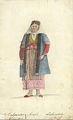
Greek Macedonia incorporates most of the territories of ancient Macedon, a Greek kingdom ruled by the Argeads, whose most celebrated members were Alexander the Great and his father Philip II. Before the expansion of Macedonia under Philip in the 4th century BC, the kingdom of the Macedonians covered an area corresponding roughly to the administrative regions of Western and Central Macedonia in modern Greece. The name Macedonia was later applied to a number of widely-differing administrative areas in the Roman and Byzantine empires. With the gradual conquest of south-eastern Europe by the Ottomans in the late 14th century, the name of Macedonia disappeared as an administrative designation for several centuries and was rarely displayed on maps. With the rise of nationalism in the Ottoman Empire, the name Macedonia was revived in the nineteenth century as a geographical term, and for educated Greeks it corresponded to the ancient historical land. The economic ascent of Thessaloniki and of the other urban centres of Macedonia coincided with the cultural and political renaissance of the Greeks. The leader and coordinator of the Greek Revolution in Macedonia was Emmanouel Pappas from Dovista (in Serres), and the revolt spread from Central to Western Macedonia. Letters from the period show Pappas either being addressed or signing himself as "Leader and Defender of Macedonia" and is today considered a Greek hero along with the unnamed Macedonians that fought with him. The fall and massacre of Naoussa marked the end of the Greek Revolution in Macedonia, and the region remained in the Ottoman empire. In the early 20th century the region was already a national cause, contested among the states of Greece, Bulgaria and Serbia. After the Macedonian Struggle and the Balkan Wars (in 1912 and 1913), the modern Greek region of Macedonia became part of the modern Greek state in 1912–13, in the aftermath of the Balkan Wars and the Treaty of Bucharest (1913). It continued as an administrative division of Greece until the reform of 1987, when it was split into the second-level administrative divisions of Western Macedonia and Central Macedonia; while the eastern part, into the Drama-Kavala-Xanthi Super-prefecture until 2010, and part of the Eastern Macedonia and Thrace division after 2010. The region is further divided between the third-level administrative divisions of the Decentralized Administration of Macedonia and Thrace, and the Decentralized Administration of Epirus and Western Macedonia. It also includes the autonomous monastic community of Mount Athos, which is under the jurisdiction of the Ministry of Foreign Affairs (through the civil administrator of Mount Athos) in its political aspect, and of the Ecumenical Patriarch of Constantinople in its religious aspect.
The region remains an important economic centre for Greece. Greek Macedonia accounts for the majority of Greece's agricultural production and is also a major contributor to the country's industrial and tourism sectors. The metropolis of the region, Thessaloniki is the second-largest city and a major economic, industrial, cultural, commercial and political centre of Greece. Central Macedonia is Greece's fourth-most-popular tourist region and the most popular destination that is not an island. It is home to four UNESCO World Heritage sites, including Aigai (modern day Vergina, about 12 km (7 mi) from Veria), one of the ancient Macedonian capital cities, where the tomb of Philip II of Macedon is located. Pella (about 1 km (0.62 mi) from modern town of Pella and about 7 km (4.3 mi) from Giannitsa), which replaced Aigai as the capital of Macedon in the fourth century BC and was the birthplace of Alexander the Great, is also located in Greek Macedonia.
 Continue reading on Wikipedia