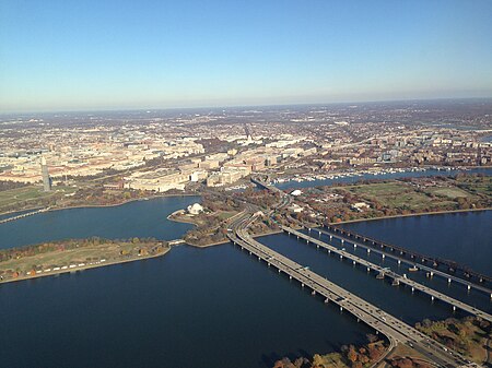
14th Street bridges

The 14th Street bridges refers to the three bridges near each other that cross the Potomac River, connecting Arlington, Virginia and Washington, D.C. Sometimes the two nearby rail bridges are included as part of the 14th Street bridge complex. A major gateway for automotive, bicycle and rail traffic, the bridge complex is named for 14th Street (U.S. Route 1), which feeds automotive traffic into it on the D.C. end. The complex contains three four-lane automobile bridges — including, from west to east, one southbound, one bi-directional, and one northbound — that carry Interstate 395 (I-395) and U.S. Route 1 (US 1) traffic, as well as a bicycle and pedestrian lane on the southbound bridge. In addition, the complex contains two rail bridges, one of which carries the Yellow Line of the Washington Metro; the other of which, the only mainline rail crossing of the Potomac River to Virginia, carries a CSX Transportation rail line. The five bridges, from west to east are the George Mason Memorial Bridge, the Rochambeau Bridge, the Arland D. Williams, Jr. Memorial Bridge, the Charles R. Fenwick Bridge and the Long Bridge. At the north end of the bridges, in East Potomac Park, the three roadways connect to a pair of two-way bridges over the Washington Channel into downtown Washington, one connecting to traffic (including northbound US 1) north onto 14th Street, and the other connecting to I-395 traffic on the Southwest Freeway. The Metro line connects to a tunnel in the East Potomac Park, and the main line railroad from the Long Bridge passes over I-395 and runs over the Washington Channel just downstream of the 14th Street approach before turning northeast along the line of Maryland Avenue. On January 13, 1982, 78 people were killed when Air Florida Flight 90 clipped the northbound I-395 span of the 14th Street bridge during rush hour and crashed into the Potomac river. The repaired span was renamed in honor of Arland D. Williams Jr., a passenger on the plane who survived the initial crash, but drowned after repeatedly passing a helicopter rescue line to other survivors.
Excerpt from the Wikipedia article 14th Street bridges (License: CC BY-SA 3.0, Authors, Images).14th Street bridges
395 Express Lane, Washington
Geographical coordinates (GPS) Address Nearby Places Show on map
Geographical coordinates (GPS)
| Latitude | Longitude |
|---|---|
| N 38.876 ° | E -77.041 ° |
Address
Rochambeau Bridge
395 Express Lane
20228 Washington
District of Columbia, United States
Open on Google Maps


