place

Trinity Catholic College, Dunedin

1871 establishments in New ZealandCatholic secondary schools in DunedinCongregation of Christian Brothers in New ZealandCongregation of Christian Brothers secondary schoolsDominican schools in New Zealand
Educational institutions established in 1871Harv and Sfn no-target errorsJesuit secondary schools in New ZealandSecondary schools in DunedinSexual abuse cover-upsSisters of Mercy schools

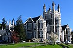
Trinity Catholic College (known as Kavanagh College before 2023) is a Catholic, state-integrated, co-educational, secondary school located in central Dunedin, New Zealand. The school was founded in 1989 as the successor of several other secondary (and one intermediate) schools the oldest of which was founded in 1871. Trinity is the only Catholic secondary school in Dunedin and is open to enrolments from throughout the entire city. The school's proprietor is the Bishop of Dunedin.

Excerpt from the Wikipedia article Trinity Catholic College, Dunedin (License: CC BY-SA 3.0, Authors).

Trinity Catholic College, Dunedin
Rattray Street, Dunedin City Rise

Geographical coordinates (GPS) Address Website External links Nearby Places
placeShow on map

Wikipedia: Trinity Catholic College, DunedinContinue reading on Wikipedia

Geographical coordinates (GPS)

Latitude Longitude
N -45.87413 ° E 170.496453 °
placeShow on map

Address

Trinity Catholic College

Rattray Street 340
9016 Dunedin, City Rise
Otago, New Zealand
mapOpen on Google Maps

Website
kavanagh.school.nz

linkVisit website

linkWikiData (Q6379085)
linkOpenStreetMap (7537703)

Share experience

Nearby Places

Arthur Street Cemetery

Arthur Street cemetery was the first cemetery built in Dunedin, New Zealand. It is situated on the City Rise, on the corner of Arthur Street and Rattray Street, on the slopes overlooking the city's centre, which lies 500 metres to the east. The first burial at the site was of surveyor's labourer James Campbell, buried on October 29, 1846, over a year before the settlement of Dunedin was founded in 1848. Coincidentally, the first christening service to be held in Dunedin occurred on the same day; both services were conducted by Rev. Charles Creed.The cemetery served the young settlement until the early 1860s, when the rapid expansion of Dunedin due to the Central Otago Gold Rush made its location inconvenient. The cemetery was closed and the remains relocated in 1865. The location of the cemetery is marked by an obelisk, erected in 1880, which is modelled on London's Cleopatra's Needle. The monument lists the names of the 60 or so known burials at the site. Many of those buried were children, and several were people who died at sea on their way to New Zealand. The site has been used for several purposes since the cemetery closed, notably a military barracks during the 1860s, a meteorological station, and a lunatic asylum. Middle District School, one of the city's first (now Arthur Street School), moved to occupy part of the site in 1877.The site is now partly in the grounds of Otago Boys' High School and partly a public park, Arthur Street Reserve.

City Rise
City Rise

City Rise is an inner suburb of the New Zealand city of Dunedin. One of the city's older suburbs, it is, as its name suggests, centred on the slopes which lie close to the city centre, particularly those closest to the city's original heart of The Exchange (for this reason, places are said to be on the City Rise rather than in City Rise). Extensive views across the central city can be gained from much of City Rise. The name City Rise is generally applied to the area immediately to the west of Princes Street, especially to the approximately triangular area of one square kilometre bounded by Princes Street and the city's Town Belt, with Maitland Street and Stuart Street lying at the edge of the area. Some parts of the lower slopes at one time carried the name Fernhill, a term still occasionally encountered to refer to this area, arising from the name of the residence of an early settler, Captain Bellairs. Other notable streets on the City Rise include High Street, Rattray Street, Stafford Street, Arthur Street, Canongate, and Serpentine Avenue. The name City Rise is sometime used to cover a wider area extending further to the north along the inner edge of the Town Belt from Stuart Street and Moana Pool as far as the stately house Olveston and to the top of Pitt Street. City Rise contains many of the city's earliest grand residences, notably along High Street and streets close to it. Many of these buildings were built on money which flowed into the infant city at the time of the Central Otago Gold Rush of 1861–1862. Notable houses include Threave (designed by Robert Lawson), Moata, and Colquhouns, among many others. The suburb is bounded by the central city to the east and northeast, by Kensington to the south, and Mornington to the west. The small suburb of Belleknowes lies immediately to the north, beyond which is Roslyn. The suburb is mainly residential, though it also has strong links with the city's education. Otago Boys' High School lies close to Stuart Street in the north of City Rise, and the original site of Otago Polytechnic (or, as it was at the time, King Edward Technical College) is also on the city rise side of Stuart Street. Otago Girls' High School is located closer to the city centre at the edge of City Rise. Arthur Street School is also located in the suburb, close to Otago Boys' High School. Next to Arthur Street School's grounds is a monument on what was the site of Dunedin's first cemetery, Arthur Street Cemetery. There is very little industry centred on City Rise, the most notable exception being Speight's Brewery, which is located at the foot of the rise close to the exchange. Immediately above this is St. Joseph's Cathedral, the city's Roman Catholic cathedral. Notable historical industrial connections with the suburb include Choie (Charles) Sew Hoy's importing company and the Kempthorne Prosser chemical manufacturing company, both of which had their main offices on Stafford Street. From the 1880s until the 1950s, City Rise was served by Dunedin's cable tramway, with lines running up from the Exchange to the hill suburbs of Mornington and Roslyn via Stuart Street and Rattray Street. The tramway was notable for being only the second of its type in the world (after the San Francisco cable car system).

Moana Pool
Moana Pool

Moana Pool is the largest swimming pool in the southern half of New Zealand's South Island. It is located at the corner of Littlebourne Road and Upper Stuart Street close to Otago Boys' High School, on the slopes of Roslyn, overlooking the centre of the city of Dunedin. The pool complex can be seen from much of the city, and commands extensive views over central and coastal Dunedin. The largest of Dunedin's four public pools, Moana Pool was built in the early 1960s on the site of the old Moana Tennis Club, Its name (the Māori word for "sea") is thus coincidentally related to the pool's facilities. It was opened on 14 November 1964. Costing £450,000, the pool was a replacement for the 1914 tepid pools in Lower Moray Place, which were seen as being inadequate for the city's modern needs. Several proposals for new pool facilities were put forward during the 1950s, mainly incorporating a suite of pools and a gymnasium surrounded by a sun terrace. A 1959 proposal, with an indoor main pool and learners' pool and an outdoor diving pool was put forward in 1959, and - with an amendment to place the diving pool under cover - was agreed by the Dunedin City Council. Initial design work by architect Bill Hesson and Ian Ballantyne of the Council's engineering department was completed by mid 1961, and work by Downer & Company began on construction shortly thereafter. The pool complex has undergone several expansions since its opening in 1964, at which time only the main pool and diving pool were complete. The main pool is of Olympic dimensions (50m by 17.5m), and is kept heated to 28.5 degrees Celsius. It can be divided by a moveable bulkhead into two 25m pools; The original diving pool, which is still in use, is 13m by 7.2m with two 1m boards, a 3m board and a high 5m platform. The learners' pool was competed and opened in 1965, and a small restaurant was added to the facilities in the same year. Between 1984 and 1990, two hydroslides were added to the complex, and additions to the learners pool to encourage young families were also made. The restaurant was removed in 1991, replaced by gym facilities, and the sun terrace was revamped, removing two trampolines which had been located there. The gym's facilities were extensively enlarged in 2006.A major expansion to the complex in 2000–01 was undertaken under the supervision of city council architect Robert Tongue. This removed much of the sun terrace, replacing it with a wave pool and leisure complex, revamped and upgraded much of the complex's reception area, and extended the main pool complex with the addition of new, Olympic-standard, diving facilities. The new 25m by 14m dive/lap pool includes three platforms (10, 7.5, and 5 metre) and four springboards (two at 3 metres, two at one metre). When not in use for diving, this pool converts into s six-lane lap pool.Moana Pool has been used for regional and national championships in swimming, diving, and water polo, and is a regular host of the New Zealand Masters' Games, which are held in Dunedin every two years. Two of the pools within the Moana Pool complex were renamed in November 2010 to honour double-Olympic gold medallist Danyon Loader and noted coach Duncan Laing, who spent much of their careers training and working at Moana Pool.

Dunedin Town Belt
Dunedin Town Belt

The Town Belt is a green belt which surrounds the centre of the New Zealand city of Dunedin. Covering a total of over 200 hectares (490 acres), it extends around three sides of the city's centre at a distance from it of some 1-3 km (1-2 mi) in a broad 7 km (4 mi) crescent from the Oval at Kensington in the south through the suburbs of Mornington, City Rise, Belleknowes, Roslyn, Maori Hill, Prospect Park, Glenleith, Woodhaugh, The Gardens and Dunedin North and the slopes of Signal Hill. The fourth side of the central city is bounded by the Otago Harbour. One of the world's oldest green belts, the Town Belt was planned in Scotland at the time of the advent of the Otago settlement in 1848. Residential areas outside the belt became separate boroughs, and were not amalgamated with Dunedin until much later. The town belt now forms a break between the city's inner and outer suburbs. The belt was originally a combination of native bush and scrubland, but is now largely replanted forest and open parkland. Many species of plant can be found in the belt, including tree fuchsia, lemonwood, lancewood, manuka, and broadleaf, and the forested area is home to many species of birds, including some uncommon and endangered species such as the kererū, eastern rosella, bellbird, tomtit, tūī, rifleman, morepork, and shining cuckoo, and kōtare. A long, narrow road, Queens Drive, winds along much of the length of the belt and provides easy access to it for Dunedinites. Queens Drive is linked to many of the city's main streets, including Stuart Street and High Street. Numerous walkways lead through the bush and parks, and the belt is a popular recreation area for Dunedinites. The Town Belt includes many open areas and parks, including the Kensington Oval, Dunedin Southern Cemetery, Montecillo Ground, Unity Park, Mornington Ground, Jubilee Park, Belleknowes Golf Course, Robin Hood Park, Littlebourne Ground, Prospect Park, Woodhaugh Gardens, the North Ground, Dunedin Botanic Gardens, Dunedin Northern Cemetery, Logan Park, and the University Oval. Notable buildings and structures in the belt include Moana Pool, Olveston, Otago Boys' High School, and the Beverly-Begg Observatory.