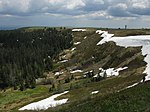
Alpine Path
Breisgau-HochschwarzwaldHiking trails in Baden-WürttembergTransport in the Black Forest

The Alpine Path (German: Alpine Pfad or Alpine Steig) is one of the highest hiking trails in the Black Forest. Between Hüttenwasen and Stübenwasen the path runs largely horizontally across the rocky northern mountainside of the Feldberg in southern Germany. The trail is 3½ kilometres long and was abandoned by the forestry authorities in order to encourage the development of nature.
Excerpt from the Wikipedia article Alpine Path (License: CC BY-SA 3.0, Authors, Images).Alpine Path
Lachenwasenweg,
Geographical coordinates (GPS) Address Nearby Places Show on map
Geographical coordinates (GPS)
| Latitude | Longitude |
|---|---|
| N 47.8704347 ° | E 7.9679157 ° |
Address
Stübenwasenkreuz
Lachenwasenweg
79674
Baden-Württemberg, Germany
Open on Google Maps


