place

Neuenkirchen-Vörden

Municipalities in Lower SaxonyVechta (district)Weser-Ems region geography stubs
Neuenkirchen Vörden in VEC

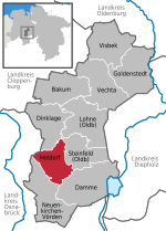
Neuenkirchen-Vörden (until 1993 Neuenkirchen (Oldenburg)) is a municipality in the district of Vechta, in Lower Saxony, Germany. It is situated approximately 30 km southwest of Vechta, and 30 km north of Osnabrück.

Excerpt from the Wikipedia article Neuenkirchen-Vörden (License: CC BY-SA 3.0, Authors, Images).

Neuenkirchen-Vörden
Buchenweg, Neuenkirchen-Vörden Neuenkirchen (Neuenkirchen)

Geographical coordinates (GPS) Address Nearby Places
placeShow on map

Wikipedia: Neuenkirchen-VördenContinue reading on Wikipedia

Geographical coordinates (GPS)

Latitude Longitude
N 52.516666666667 ° E 8.0666666666667 °
placeShow on map

Address

Buchenweg
49434 Neuenkirchen-Vörden, Neuenkirchen (Neuenkirchen)
Lower Saxony, Germany
mapOpen on Google Maps

Neuenkirchen Vörden in VEC
Share experience

Nearby Places

Battle of the Teutoburg Forest

The Battle of the Teutoburg Forest, described as the Varian Disaster (Latin: Clades Variana) by Roman historians, was a major battle between Germanic tribes and the Roman Empire that took place somewhere near modern Kalkriese from September 8–11, 9 AD, when an alliance of Germanic peoples ambushed three Roman legions led by Publius Quinctilius Varus and their auxiliaries. The alliance was led by Arminius, a Germanic officer of Varus's auxilia. Arminius had acquired Roman citizenship and had received a Roman military education, which enabled him to deceive the Roman commander methodically and anticipate the Roman army's tactical responses. Teutoburg Forest is commonly seen as one of the most important defeats in Roman history, bringing the triumphant period of expansion under Augustus to an abrupt end. The outcome of this battle dissuaded the Romans from their ambition of conquering Germania, and is thus considered one of the most important events in European history. The provinces of Germania Superior and Germania Inferior, sometimes collectively referred to as Roman Germania, were subsequently established in northeast Roman Gaul, while territories beyond the Rhine remained independent of Roman control. Retaliatory campaigns were commanded by Tiberius and Germanicus and would enjoy success, but the Rhine would eventually become the border between the Roman Empire and the rest of Germania. The Roman Empire would launch no other major incursion into Germania until Marcus Aurelius (r. 161–180) during the Marcomannic Wars.Some of the descendants of the vassal kingdoms, like the Suebi (by suzerainty), that Augustus tried to create in Germania to expand the romanitas and the Empire would be the ones that invaded the Empire in the fourth and fifth centuries.

Kalkriese
Kalkriese

Kalkriese is a village now administratively part of the city of Bramsche in the district of Osnabrück, Lower Saxony, Germany. It is on the northern slope of the Wiehen Hills, a ridge-like range of hills, north of Osnabrück. The Kalkrieser Berg or Schmittenhöhe, a hill with a height of 157 m (515 ft), is considered by archaeologists to be the likely site of the Battle of the Teutoburg Forest. The Battle of the Teutoburg Forest (German: Schlacht im Teutoburger Wald, Hermannsschlacht or Varusschlacht), described as clades Variana (the "Varian disaster") by Roman historians, took place in what the Romans called the saltus Teutoburgiensis and has since been identified as Kalkriese in 9 AD, when an alliance of Germanic tribes ambushed and decisively destroyed three Roman legions and their auxiliaries, led by Publius Quinctilius Varus. The anti-Roman alliance was led by Arminius, an officer of Varus' auxiliary forces who had acquired Roman citizenship and received a Roman military education. The Romans' saltus Teutoburgiensis (Teutoburg Pass) is taken to refer to the strip of cultivated land with a width of 220 m (720 ft) which lies between the Kalkrieser Berg and a large area of wetland to its north, the great bog of Großes Moor. The passage along the northern slope of the Kalkrieser Berg is a difficult one because of the need to cross many deep brooks and rivulets. Since the start of official explorations in 1988 more than 5,500 Roman objects, mainly pieces of military equipment, have been found in an area covering 17 km2 (6.6 sq mi): The objects include Roman swords and daggers, parts of javelins and spears, arrowheads, sling stones, fragments of helmets, soldiers' boot nails, belts, chainmail hooks, and fragments of armor. Among the most significant items is the earliest known Imperial face-mask. Other items include locks, keys, razors, a scale, weights, chisels, hammers, pickaxes, buckets, finger rings, surgical instruments, seal boxes, a stylus, cauldrons, casseroles, spoons, and amphorae. Jewelry, hairpins, and a disk brooch suggest the presence of women. One of the inscribed objects is a plumb bob with "CHOI", or "C(o)HO(rtis) I", i.e. "property of the first cohort". The other one is a chainmail fastener with the inscription: "M AIUS (cohortis) I (centuriae) FABRICI(i) M AII (cohortis) I (centuriae) FAB(ricii)" ("Marcus Aius of cohort I, centuria of fabricii; property of Marcus Aius of cohort I, centuria of fabricii"). A coin struck to commemorate Augustus's adoption of his grandsons Lucius and Gaius in 2 BC has also been found at Kalkriese. In 2016, an archaeological investigation found eight aurei close together at the site, adding to the seven Roman gold coins previously found and tending to corroborate the identification of Kalkriese as the site of the battle.