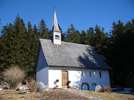
St. Martin's Chapel, Furtwangen
Buildings and structures in Schwarzwald-Baar-KreisHeritage sites in Baden-WürttembergRoman Catholic chapels in GermanyRoman Catholic churches in Baden-Württemberg

St. Martin’s Chapel (German: Martinskapelle) stands at an elevation of 1,085 metres above sea level (NHN) at the upper end of the Katzensteig valley on the territory of Furtwangen just above the source of the Danube. It is also not far from the source of the River Elz and thus the main European watershed between the Rhine and the Danube. The West Way, a major hiking trail in the Black Forest runs past the chapel as does the long-distance ski trail from Schonach to Belchen.
Excerpt from the Wikipedia article St. Martin's Chapel, Furtwangen (License: CC BY-SA 3.0, Authors, Images).St. Martin's Chapel, Furtwangen
Neuweg, Verwaltungsgemeinschaft Furtwangen im Schwarzwald
Geographical coordinates (GPS) Address External links Nearby Places Show on map
Geographical coordinates (GPS)
| Latitude | Longitude |
|---|---|
| N 48.096138888889 ° | E 8.1555833333333 ° |
Address
Martinskapelle
Neuweg 9
78120 Verwaltungsgemeinschaft Furtwangen im Schwarzwald
Baden-Württemberg, Germany
Open on Google Maps


