place

Warrior Creek (Pennsylvania)

Rivers of Luzerne County, PennsylvaniaRivers of PennsylvaniaTributaries of the Susquehanna River
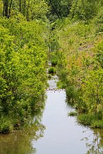
Warrior Creek looking upstream

Warrior Creek is a tributary of the Susquehanna River in Luzerne County, Pennsylvania, in the United States. It is approximately 3.0 miles (4.8 km) long and flows through Warrior Run, Sugar Notch, and Hanover Township. The watershed of the creek has an area of 4.51 square miles (11.7 km2). It is designated as a Coldwater Fishery. However, it is considered to be impaired by abandoned mine drainage. The surficial geology in the creek's vicinity consists of alluvium, fill, urban land, strip mining land, Wisconsinan Till, and bedrock.

Excerpt from the Wikipedia article Warrior Creek (Pennsylvania) (License: CC BY-SA 3.0, Authors, Images).

Warrior Creek (Pennsylvania)
Sans Souci Parkway, Wilkes-Barre

Geographical coordinates (GPS) Address Nearby Places
placeShow on map

Wikipedia: Warrior Creek (Pennsylvania)Continue reading on Wikipedia

Geographical coordinates (GPS)

Latitude Longitude
N 41.21295 ° E -75.97457 °
placeShow on map

Address

Dundee Beverage

Sans Souci Parkway 2297
18706 Wilkes-Barre
Pennsylvania, United States
mapOpen on Google Maps

Warrior Creek looking upstream
Share experience

Nearby Places

Nanticoke Creek
Nanticoke Creek

Nanticoke Creek is a tributary of the Susquehanna River in Luzerne County, Pennsylvania, in the United States. It is approximately 4.4 miles (7.1 km) long and flows through Hanover Township and Nanticoke. The watershed of the creek has an area of 7.57 square miles (19.6 km2). The creek has one named tributary, which is known as Espy Run. Nanticoke Creek impaired by pH and metals due to abandoned mine drainage. Abandoned mine drainage discharges in the creek's watershed include the Truesdale Mine Discharge and the Askam Borehole. The creek is located in the Northern Middle Anthracite Field and is in the Anthracite Valley Section of the ridge and valley physiographic province. The main rock formations in the watershed include the Mauch Chunk Formation, the Pottsville Group, and the Llewellyn Formation. The surficial geology consists of coal dumps, surface mining land, alluvium, Wisconsinan Outwash, Wisconsinan Till, urban land, and bedrock. The watershed of Nanticoke Creek is mainly forested, but urban land and mining land are also present. The city of Nanticoke is partially in the watershed and many unincorporated communities are there as well. The creek is named after the Nanticoke tribe, but was historically known as Muddy Run before appearing on maps with its present name by 1776. Extensive mining, both underground and on the surface, has been done in the creek's watershed. Numerous passive and active treatment systems have been installed in the watershed in recent times. Nanticoke Creek is designated as a Coldwater Fishery and a Migratory Fishery. However, it is relatively lacking in aquatic life.