place

Bunde, Germany

Holocaust locations in GermanyLeer (district)Municipalities in Lower SaxonyRheiderlandTowns and villages in East Frisia
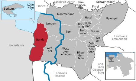
Bunde in LER
Bunde in LER

Bunde is a municipal district in East Frisia, in Lower Saxony, Germany, about 20 km (12 mi) south of Emden, Germany, and 50 km (30 mi) east of Groningen, Netherlands. It lies on the southern tip of the Dollart, a bay of the North Sea between Germany and the Netherlands, and has a land border with the Netherlands. Bunde is among the smaller districts of East Frisia, with a population of 7,607 (as of 2015). About half live in the town of Bunde itself. The district's population density is comparatively low at 62/km2 (160/sq mi), compared with 228/km2 (590/sq mi) for Germany as a whole. In the 17th and 18th centuries, sizeable areas of the district were wrested from the sea by the creation of polders. Bunde's economy centers on agriculture and tourism. The community has been officially recognized as a resort town since 1998. Many of the town's residents commute to jobs elsewhere, notably in Leer, about 13 km (8 mi) to the east. Residents include a number of Dutch nationals, most of whom commute to jobs in the Netherlands. The town's cultural artifacts include the Reformed Church (Reformierte Kreuzkirche), the nave of which dates from the 13th century, and the red brick Steinhaus Bunderhee castle, which dates from the 14th century.

Excerpt from the Wikipedia article Bunde, Germany (License: CC BY-SA 3.0, Authors, Images).

Bunde, Germany
Neuschanzer Straße,

Geographical coordinates (GPS) Address Nearby Places
placeShow on map

Wikipedia: Bunde, GermanyContinue reading on Wikipedia

Geographical coordinates (GPS)

Latitude Longitude
N 53.183333333333 ° E 7.2666666666667 °
placeShow on map

Address

Neuschanzer Straße 11
26831
Lower Saxony, Germany
mapOpen on Google Maps

Bunde in LER
Bunde in LER
Share experience

Nearby Places

IJkdijk
IJkdijk

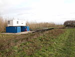
The IJkdijk is a facility in the Netherlands to test dikes and to develop sensor network technologies for early warning systems. Furthermore, the sensor network will be able to detect many water-related environmental factors that affect the health of humans such as pollution and biological changes. Disasters on rivers and coastal waters are also detected. In studies of dike stability, about eighty dikes will be destroyed and establish, ultimately, a relation between the sensor readings and the future of the dike. Hence the (in Dutch) good-sounding name IJkdijk: dijk=dike and ijk is from the Dutch word ijken=to calibrate (models). Clearly the most urgent goal here is to forecast dike failures. In contrast to popular belief, most disasters with dikes occur because they are too wet and not because they are too low. Another major source of dike failures are streams of water flowing through the dike, ultimately destroying, through erosion, the dike from the inside. A detection system for these failure mechanisms might be cheaper and safer than the alternative: over-dimensioning by adding more clay. As dike improvements are very costly, e.g. 500 euros per meter, there is ample financial room to pay for the sensor system. The IJkdijk will also increase the geophysical understanding of dike behavior. A better understanding of dikes, expressed in a sensor-based early warning system in dikes, prevents unnecessary and costly over-dimensioning. That is good news for the owners of millions of kilometers of dikes that exist nowadays and the developers of millions of kilometers of dikes that will be constructed in the future.