place

Chadderton

ChaddertonEngvarB from July 2019Geography of the Metropolitan Borough of OldhamTowns in Greater ManchesterUnparished areas in Greater Manchester
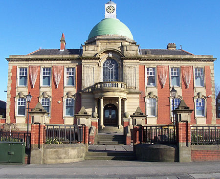
Chadderton Town Hall (front)

Chadderton is a town in the Metropolitan Borough of Oldham, Greater Manchester, England, on the River Irk and Rochdale Canal. It is located in the foothills of the Pennines, 1 mile (1.6 km) west of Oldham, 5 miles (8.0 km) south of Rochdale and 6 miles (9.7 km) north-east of Manchester. Historically part of Lancashire, Chadderton's early history is marked by its status as a manorial township, with its own lords, who included the Asshetons, Chethams, Radclyffes and Traffords. Chadderton in the Middle Ages was chiefly distinguished by its two mansions, Foxdenton Hall and Chadderton Hall, and by the prestigious families who occupied them. Farming was the main industry of the area, with locals supplementing their incomes by hand-loom woollen weaving in the domestic system. Chadderton's urbanisation and expansion coincided largely with developments in textile manufacture during the Industrial Revolution and the Victorian era. A late-19th century factory-building boom transformed Chadderton from a rural township into a major mill town and the second most populous urban district in the United Kingdom. More than 50 cotton mills had been built in Chadderton by 1914. Although Chadderton's industries declined in the mid-20th century, the town continued to grow as a result of suburbanisation and urban renewal. The legacy of the town's industrial past remains visible in its landscape of red-brick cotton mills, now used as warehouses or distribution centres. Some of these are listed buildings because of their architectural, historical and cultural significance.

Excerpt from the Wikipedia article Chadderton (License: CC BY-SA 3.0, Authors, Images).

Chadderton
Burnley Street,

Geographical coordinates (GPS) Address Website Nearby Places
placeShow on map

Wikipedia: ChaddertonContinue reading on Wikipedia

Geographical coordinates (GPS)

Latitude Longitude
N 53.5462 ° E -2.1426 °
placeShow on map

Address

Chadderton Wellbeing Centre

Burnley Street
OL9 0JW , Busk
England, United Kingdom
mapOpen on Google Maps

Website
oclactive.co.uk

linkVisit website

Chadderton Town Hall (front)
Share experience

Nearby Places

Nordens
Nordens

Nordens is a suburban area of Chadderton in the Metropolitan Borough of Oldham, Greater Manchester.Lying in a valley archaically known as Hunt Clough, Nordens is located around the junction of Middleton Road and Hunt Lane, around 0.7 miles to the west of Chadderton's commercial centre on Middleton Road and is contiguous with the Chadderton Park, Firwood Park and Stock Brook areas of the town. Semi-rural Foxdenton lies to the south.The name Nordens derives from North Dene or Valley and is commemorated in the name North Dene Park, a street name in the district.Nordens Lane (later Nordens Road), a short stretch of which still exists as Nordens Street, was one of Chadderton's oldest roads and was one of the main routes leading to the nearby Chadderton Hall manor house. Suburban housing now lies on the land the lane went through.Between the mid-1960s and 1992 Nordens Road was the home ground of the now-defunct Oldham Town Football Club (previously known as Oldham Dew) who played in the North West Counties League. The ground is now open space, the club has relocated to the Whitebank Stadium in Oldham. The Radclyffe School lies in the vicinity of this district. The Hunt Lane Tavern is a public house in the area, dating back to 1854. The pub has its origins in a farmhouse which was situated in Hunt Clough. This was a valley through which ran the stream known as Spring Brook. The pub, first licensed in 1840, was in the area of Hunt Clough now built over by the Swallow Fields housing development off Middleton Road. Adjacent to the pub lies the former Nordens Branch of the Co-operative Wholesale Society dating from the early 20th century although the building is now used for other retail purposes.The extensive Chadderton Cemetery, which opened in 1857, lies in close vicinity at Spring Brook. The Spring Brook Works, a major finishing factory, also lay at Spring Brook just off Nordens Road. It was built in 1875, being demolished in 1985. Suburban housing now covers this area.In 1914 a branch of the now-defunct Middleton Junction and Oldham Branch Railway to Chadderton Coal and Mineral Yard opened necessitating the realignment of Hunt Lane so as to enter Middleton Road further west. Thus it no longer faced the Hunt Lane Tavern pub. This confuses people to this day with the Hunt Lane Chippy and the Hunt Lane Tavern no longer being adjacent to the lane of that name.