place

Moulton End

North Yorkshire geography stubsUse British English from August 2020Villages in North Yorkshire
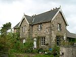
Moulton Station, North Yorkshire

Moulton End is a hamlet in North Yorkshire, in England. The hamlet gradually built up around the now disused railway station formerly serving North Cowton. The station was part of the disbanded Eryholme-Richmond branch line, which also used to serve Catterick Garrison. The station building is now a residential property, the platform clock is still visible on the wall of the Station house. The Darlington-bound platform still survives, but it is heavily overgrown with trees and bushes. The Richmond platform has been incorporated into a boundary wall to Station House.

Excerpt from the Wikipedia article Moulton End (License: CC BY-SA 3.0, Authors, Images).

Moulton End
Back Lane,

Geographical coordinates (GPS) Address Nearby Places
placeShow on map

Wikipedia: Moulton EndContinue reading on Wikipedia

Geographical coordinates (GPS)

Latitude Longitude
N 54.429936 ° E -1.579166 °
placeShow on map

Address

Moulton

Back Lane
DL10 6QL , North Cowton
England, United Kingdom
mapOpen on Google Maps

Moulton Station, North Yorkshire
Share experience

Nearby Places

Dalton-on-Tees
Dalton-on-Tees

Dalton-on-Tees is a village and civil parish in the Richmondshire district of North Yorkshire, England, near the boundary with County Durham. According to the 2001 Census there were 318 people living in the parish (including Eryholme) in 120 houses. The population had decreased to 303 by the time of the 2011 Census.The village is bypassed by the A167 road between Darlington and Northallerton and is 1+1⁄2 miles (2.4 km) south of the village of Croft-on-Tees and 1 mile (1.6 km) north-east of the motor racing circuit Croft Circuit. There are signs at both the north and south entrances to the village indicating that the village is 11+1⁄4 miles (18.1 km) from Northallerton and 4+3⁄4 miles (7.6 km) from Darlington even though they are 1⁄4 mile (0.4 km) apart. To the east the village overlooks a meander of the River Tees, from which it derives its name: the town (tun) in the valley (or dæl [dale]).The village has a pub, the Chequers Inn, overlooking the village green, and a small village hall on the other side of the bypass just along West Lane. The village green is the site of the village pump (now defunct) which stands under a sprawling chestnut tree. There are a number of signed streets in the village, namely, Ruskin Close, Byron Court, Garth Terrace, Orchard Close and West Lane, and a number of unsigned roads and lanes, including The Green and the Old Road. The parish had 133 properties at the 2011 Census but new estates have been built in the village since then. Dalton-on-Tees is served by the number 72 public bus between Darlington and Northallerton and on school days the number 466R between Croft-on-Tees and Richmond School. The village has a series of moats, identified as a fishpond complex dating back to Medieval times.