Tunnel valley

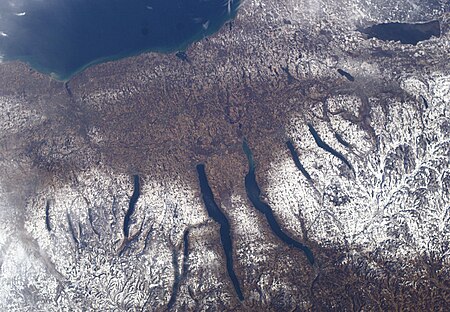
A tunnel valley is a U-shaped valley originally cut under the glacial ice near the margin of continental ice sheets such as that now covering Antarctica and formerly covering portions of all continents during past glacial ages. They can be as long as 100 km (62 mi), 4 km (2.5 mi) wide, and 400 m (1,300 ft) deep. Tunnel valleys were formed by subglacial erosion by water and served as subglacial drainage pathways carrying large volumes of meltwater. Their cross-sections often exhibit steep-sided flanks similar to fjord walls. They presently appear as dry valleys, lakes, seabed depressions, and as areas filled with sediment. If they are filled with sediment, their lower layers are filled primarily with glacial, glaciofluvial or glaciolacustrine sediment, supplemented by upper layers of temperate infill. They can be found in areas formerly covered by glacial ice sheets including Africa, Asia, North America, Europe, Australia and offshore in the North Sea, the Atlantic and in waters near Antarctica. Tunnel valleys appear in the technical literature under several terms, including tunnel channels, subglacial valleys, iceways, snake coils and linear incisions.
Excerpt from the Wikipedia article Tunnel valley (License: CC BY-SA 3.0, Authors, Images).Tunnel valley
Lakeshore Trail,
Geographical coordinates (GPS) Address Nearby Places Show on map
Geographical coordinates (GPS)
| Latitude | Longitude |
|---|---|
| N 42.6937 ° | E -76.9251 ° |
Address
U.S. Navy Seneca Lake Sonar Test Facility
Lakeshore Trail
14588
New York, United States
Open on Google Maps


