place

Härmelekopf

Mountains of Tyrol (state)Mountains of the AlpsTwo-thousanders of Austria
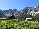
Harmelekopf from below Rosshutte 4985

The Härmelekopf is a mountain northeast of Seefeld in Tirol in the Karwendel Alps in the Austrian state of Tyrol. It is 2,224 metres high.

Excerpt from the Wikipedia article Härmelekopf (License: CC BY-SA 3.0, Authors, Images).

Härmelekopf
Kuntersteig,

Geographical coordinates (GPS) Address Nearby Places
placeShow on map

Wikipedia: HärmelekopfContinue reading on Wikipedia

Geographical coordinates (GPS)

Latitude Longitude
N 47.30833 ° E 11.22806 °
placeShow on map

Address

Kuntersteig
6103
Austria
mapOpen on Google Maps

Harmelekopf from below Rosshutte 4985
Share experience

Nearby Places

Erlspitze Group
Erlspitze Group

The Erlspitze Group (German: Erlspitzgruppe), also called the Seefeld Group, is the southwesternmost side range of the Austrian part of the Karwendel mountains in the Alps. It forms a horseshoe-shaped highland around the valley of Eppzirler Tal and is joined in the south to the Nordkette by the Erl Saddle (Erlsattel) near Solsteinhaus. It is bounded in the west by the Seefeld Basin, in the east by the valleys of the Gleirschtal and the Großes Kristental; its forested northern foothills reach as far as Scharnitz. Unlike the four main ranges of the Karwendel, the Erlspitze Group is made of Main Dolomite. Typical of this rock are bizarre weathering forms, like towers, pinnacles and sharply formed arêtes as well as rock arches and caves as a consequence of the rapid erosion of individual rock strata. Its valley bases are Hochzirl, Reith, Seefeld and Scharnitz, all of which are on the Innsbruck-Mittenwald section of the Mittenwald Railway. Two alpine club huts act as bases for tours in the area of the Erlspitze Group: in the west is the Nördlinger Hut and, in the south, is the Solsteinhaus. In the northern part of the Erlspitze Group are two huts open in summer: the Oberbrunnalm and, in the Eppzirler Tal, the Eppzirler Alm. Important peaks (by height) Erlspitze (2,405 m (AA)) Reither Spitze (2,374 m (AA)) Freiungen (2,332 m (AA)) Kuhljochspitze (2,297 m (AA)) Härmelekopf (2,224 m (AA)) Seefelder Spitze (2,221 m (AA)) Fleischbanktürme (2,216 m (AA)) Fleischbankspitze (2,206 m (AA)) Karlspitze (2,174 m (AA)) Seefelder Joch (2,060 m (AA)) Zischgenkopf (1,932 m (AA)) Zäunlkopf (1,746 m (AA))

Wildsee (Seefeld)
Wildsee (Seefeld)

The Wildsee, occasionally also called the Seefelder See ("Lake Seefeld"), is a lake near the Austrian resort of Seefeld in Tirol at the foot of the Gschwandtkopf (1,495 m). It has an area of 6.1 hectares and a maximum depth of 5.1 metres. The majority of the lake belongs to the municipality of Seefeld, its south and west shores are part of Reith bei Seefeld. The lake is fed from the Haglbach, which rises below the col of the Seefelder Joch and empties into the lake in the southeast, and water from the bog of Reither Moor and other smaller springs. Its catchment area is just under 7 km2. It is drained northwards by the Seebach which empties into the River Isar. On the east shore of the lake are small beds of reed and sedge; on the west shore mixed forest runs down to the lake. South of the lake is the Reither Moor, a raised bog resulting from the silting up of the Wildsee in which mountain pine trees grow. The south shore and the Reither Moor are a nature reserve. The Wildsee probably gave the village of Seefeld, first mentioned in 1022, its name. Emperor Maximilian I used it for fish farming and had lampreys introduced, which is why the lake also bore the name Lampretensee. The breeding of this fish, a prized delicacy at that time, only lasted for a few decades, however. Today, the Wildsee is a popular bathing lake with two beaches. According to limnological research, the lake has a low to medium nutrient content. Due to the bog-like character of the lake, visibility is only about 1 to 3 metres. In 2013 the water quality was classified as excellent.The Wildsee is threatened by silting up as a result of the sediment transported to it by the Haglbach. In future a pond will be excavated east of Innsbrucker Straße in order to trap the sediment. There is also discussion about enlarging the lake.