Kungens Kurva
Metropolitan StockholmStockholm County geography stubs

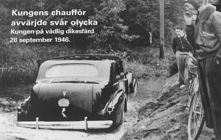
Kungens Kurva (literally, "The King's Bend" or "The King's Curve") is a part of Huddinge Municipality, in Metropolitan Stockholm, Sweden, 20 km south of the city. The area got its name on 28 September 1946, when King Gustav V's chauffeur-driven 1939 Cadillac skidded off the road and ended up in a ditch (The king was uninjured). The name later became official. The area has a large retail park, with stores such as supermarkets, electronics/hardware retailers and the world's third largest IKEA store, with, since a 2014 expansion, a total area of 63,200 square meters. It is close to Skärholmen metro station, which provides access to Stockholm.
Excerpt from the Wikipedia article Kungens Kurva (License: CC BY-SA 3.0, Authors, Images).Kungens Kurva
Södertäljevägen, Huddinge kommun
Geographical coordinates (GPS) Address Nearby Places Show on map
Geographical coordinates (GPS)
| Latitude | Longitude |
|---|---|
| N 59.268 ° | E 17.911 ° |
Address
Södertäljevägen
127 48 Huddinge kommun, Kungens kurva
Sweden
Open on Google Maps


