place

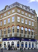
The Barley Mow, Marylebone

Buildings and structures in MaryleboneCommercial buildings completed in 1791Grade II listed pubs in the City of WestminsterLondon building and structure stubsNational Inventory Pubs
Pub stubsUnited Kingdom listed building stubsUse British English from August 2014
The Barley Mow, Marylebone 01

The Barley Mow is a grade II listed pub located at 8 Dorset Street, Marylebone, London, W1.It is on the Campaign for Real Ale's National Inventory of Historic Pub Interiors. Public houses on this list have remained relatively unchanged since World War II or at least for the past thirty years. It was built in 1791 and is rumored to be the longest standing building in Marylebone. It is also one of the last remaining free houses in central London. The Barley Mow is a pub with listed wooden booth seating, occasional live music and Saturday quizzes.

Excerpt from the Wikipedia article The Barley Mow, Marylebone (License: CC BY-SA 3.0, Authors, Images).

The Barley Mow, Marylebone
Dorset Street, London Marylebone

Geographical coordinates (GPS) Address Website Nearby Places
placeShow on map

Wikipedia: The Barley Mow, MaryleboneContinue reading on Wikipedia

Geographical coordinates (GPS)

Latitude Longitude
N 51.5197 ° E -0.1556 °
placeShow on map

Address

Acacus

Dorset Street 7A
W1U 7NG London, Marylebone
England, United Kingdom
mapOpen on Google Maps

Website
acacus-restaurant.business.site

linkVisit website

The Barley Mow, Marylebone 01
Share experience

Nearby Places

Chiltern Street
Chiltern Street

Chiltern Street is a road in the Marylebone area of Central London. Located in the City of Westminster, it runs north to south connecting Marylebone Road and Blandford Street. Baker Street runs parallel a little way to the west. It meets Dorset Street, Crawford Street and Paddington Street along its route. Manchester Square is located beyond the southern end of the street. It is part of the Portman Estate and dates back to the eighteenth century. Historically it was known as East Street, with the name changing in 1937. Until the second half of the nineteenth century it didn't run as far north as the Marylebone Road, with the short David Street and buildings blocking the route. It is one of several streets and buildings in the area with names linked to the Chiltern Hills, which were connected to Marylebone from both the Metropolitan Line and the Great Central Railway from Marylebone Station. The street shares its name with the Chiltern Court building over Baker Street tube station which was planned in 1912 but not fully constructed until the 1920s after wartime delays. An entrance to the station is located on the junction between Chiltern Street and Marylebone Road. The street features a mixture of commercial and residential buildings. At the southern end is the 1899 Grade II listed Chiltern Firehouse, formerly the Marylebone Fire Station and now converted into a restaurant. In 1864 a Welsh Methodist Chapel was opened in the street. A particular feature is the large redbrick Portman Mansions constructed in the 1890s at the northern end of the street. Notable residents of the street have included Henry Segrave the world land speed record holder in the 1920s, who is now commemorated with a blue plaque.