Long Lane, City of London
Streets in the City of LondonUse British English from May 2017

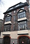
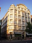
Long Lane is a street in the City of London, the historic and primary financial centre of London. It runs east–west and forms part of the B100 route. At the western end it becomes West Smithfield and in the east it becomes Beech Street, at the junction with Aldersgate Street. The street is particularly known for drinking and dining, with a pub, The Old Red Cow, at Nos. 71–72, and restaurants Chabrot at Nos. 62-63 and Apulia (formerly Morgan M) at No. 50.
Excerpt from the Wikipedia article Long Lane, City of London (License: CC BY-SA 3.0, Authors, Images).Long Lane, City of London
Long Lane, City of London
Geographical coordinates (GPS) Address Nearby Places Show on map
Geographical coordinates (GPS)
| Latitude | Longitude |
|---|---|
| N 51.5194 ° | E -0.0996 ° |
Address
Ladbrokes
Long Lane 66-67
EC1A 9EJ City of London
England, United Kingdom
Open on Google Maps


