place

Hillsborough County Registry of Deeds

Buildings and structures completed in 1901Buildings and structures in Nashua, New HampshireCourthouses in New HampshireGovernment buildings on the National Register of Historic Places in New HampshireNational Register of Historic Places in Hillsborough County, New Hampshire
NashuaNH HillsboroughCountyCourthouse

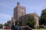
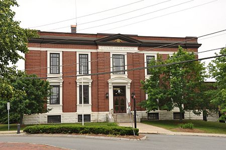
The Hillsborough County Registry of Deeds is located at 19 Temple Street in Nashua, one of the county seats of Hillsborough County, New Hampshire. The two-story brick building was built in 1901 as a courthouse and county office building to a design by Boston architect Daniel H. Woodbury, and is a good example of Classical Revival architecture. The building was listed on the National Register of Historic Places in 1985. The current courthouse is a modern building at 30 Spring Street.

Excerpt from the Wikipedia article Hillsborough County Registry of Deeds (License: CC BY-SA 3.0, Authors, Images).

Hillsborough County Registry of Deeds
Main Street, Nashua

Geographical coordinates (GPS) Address Website Nearby Places
placeShow on map

Wikipedia: Hillsborough County Registry of DeedsContinue reading on Wikipedia

Geographical coordinates (GPS)

Latitude Longitude
N 42.761388888889 ° E -71.465 °
placeShow on map

Address

Hamblett & Kerrigan

Main Street 146
03060 Nashua (Ward 4)
New Hampshire, United States
mapOpen on Google Maps

Website
nashualaw.com

linkVisit website

NashuaNH HillsboroughCountyCourthouse
Share experience

Nearby Places

Soldiers and Sailors Monument (Nashua, New Hampshire)

The Soldiers and Sailors Monument in Nashua, New Hampshire is an American Civil War memorial. Its cornerstone was laid on May 30, 1889, and the monument dedicated on October 15, 1889. The monument is located in central Nashua within the triangle formed by Concord, Amherst, and Nashville streets. The monument is a square, castellated column of New Hampshire granite from Nashua on a base of Quincy granite, atop which stands a figure of Victory, dressed in classical Roman garments and holding an American shield and a laurel wreath. Its base is ornamented with bronze statues of a soldier and sailor, and bronze reliefs depicting the Goddess of Liberty overseeing the reconciliation of the South with the North, an emancipation scene with a Union soldier extending a scroll to a kneeling figure, and the sinking of the Alabama by the Kearsarge. At its front is a sculpture of a saddle draped with cavalry clothing and equipment; at the rear is a sculpture of Civil War-era weapons. The design for the monument was made by T. M. Perry, of Messrs. Frederick & Field, who carved the Victory, erected the monument, and did all its granite work. The sailor was modeled by S. J. O'Kelley and cast by Melzar Hunt Mosman. The soldier was modeled by Caspar Buberl and cast by the Henry Bonnard Bronze Company. The artillery sculpture was made and cast by Melzar Hunt Mosman, as were the Emancipation bas-relief and the two lettered panels. The statue of Victory, cavalry sculpture, and sinking of the Alabama were modeled by Beattie & Brooks. On bronze plaque on lower front of monument: On bronze plaque on lower back of base: On relief plaque on base: On relief plaque on base:SINKING OF THE ALABAMA BY THE KEARSARGE JUNE 19, 1864

Nashville Historic District (Nashua, New Hampshire)

The Nashville Historic District in Nashua, New Hampshire is a historic district that was listed on the National Register of Historic Places (NRHP) in 1984. It encompasses an area just north of downtown Nashua, roughly centered on the junction of Concord, Amherst, and Main streets. Its southern bound is the Nashua River and Railroad Square, its eastern bounds are Railroad Square, Clinton, Lock, Orange, and Concord streets, its northern bound is Mount Pleasant Street, and its western boundary is Abbott, Amherst, Concord, and Main streets between the northern and southern bounds.Today this area is known as French Hill, but the NRHP district takes its name from a time in the 19th century when the area was briefly separated from Nashua as the town of "Nashville". This was due to the placement of a new Town Hall in the southern half of the city (which was more populated at the time). The northern contingent split themselves off, calling themselves "Nashville". The split came only six years after the town had renamed itself "Nashua", in 1836. The creation of a new railroad line from Lowell, Massachusetts, that ran along the northern length of the Nashua River had resulted in Union Square being renamed "Railroad Square" in 1838.However, the railroad brought new economic prosperity and increased communication with Boston, and in 1853 the two town committees resolved their differences and a new town charter for the "City of Nashua" was enacted.