place

List of crossings of the River Wye

Bridges across the River WyeCrossings in the United Kingdom by riverIncomplete lists from May 2014Lists of bridges in the United KingdomLists of coordinates
Use British English from December 2016
Map of the River Wye (West Midlands and Wales, UK)

Crossings of the River Wye in the UK cover the whole length of the 215 kilometres (134 mi) from its source to the River Severn. For much of its length the river forms part of the border between England and Wales. The lower Wye Valley is an Area of Outstanding Natural Beauty. There are some 15 Grade II listed bridges, one Grade II* listed bridge and three Grade I listed bridges.

Excerpt from the Wikipedia article List of crossings of the River Wye (License: CC BY-SA 3.0, Authors, Images).

List of crossings of the River Wye
Duke of Beaufort Bridge,

Geographical coordinates (GPS) Address Nearby Places
placeShow on map

Wikipedia: List of crossings of the River WyeContinue reading on Wikipedia

Geographical coordinates (GPS)

Latitude Longitude
N 51.804475 ° E -2.707872 °
placeShow on map

Address

Monmouth Viaduct

Duke of Beaufort Bridge
NP25 3LZ , Wyesham
Wales, United Kingdom
mapOpen on Google Maps

Map of the River Wye (West Midlands and Wales, UK)
Share experience

Nearby Places

Monmouth Viaduct
Monmouth Viaduct

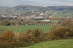
The Monmouth Viaduct or Chippenham Meadow Viaduct is a 20-arch 183m red sandstone viaduct, with two 23m steel lattice-girder spans over the river. It carried the Coleford, Monmouth, Usk & Pontypool Railway line across the River Wye at Monmouth, Wales. A further river crossing by the Ross and Monmouth Railway was later built nearby. The Coleford, Monmouth, Usk & Pontypool Railway was opened in 1857, running from Pontypool to Monmouth Troy. The single-track line was extended in 1861 to Wyesham Halt on the east side of the viaduct. The bridge which was originally planned to carry the line onwards to Coleford. However, the line terminated at Wyesham and was not extended to Coleford as the Great Western Railway and West Midland Railway did not pursue the extension. The bridge was not heavily used until 1876 when the Wye Valley Railway completed its line from Chepstow and south Wales. In 1883 the Coleford Railway was constructed from Wyesham Junction to Coleford but was closed as being uneconomical in 1916.The viaduct was originally planned to be constructed of wood, but the 1852 floods influenced the engineers to change to stone. The building of the viaduct took exactly ten months. It contains 9,000 cubic yards of masonry and 3,000 cubic yards of concrete. Two arches form the 20m long eastern element of the structure. The bridge was designed by Christopher Firbank and built by Kennards of Crumlin. It was about 50 feet above the water and lay on two 150-foot girders resting on the stone arches. Large crowds assembled to watch the bridge being put into place in 1861. Only the stone parts of the viaduct are extant today.