place

500 East station

2013 establishments in UtahRailway stations in Salt Lake County, UtahRailway stations in the United States opened in 2013UTA streetcar stopsUse mdy dates from March 2020
UTA S Line streetcars at 500 East

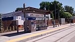
500 East is a streetcar stop in South Salt Lake, Utah, served by Utah Transit Authority's (UTA) S Line (previously known as the Sugar House Streetcar). The S Line provides service from the Sugar House neighborhood of Salt Lake City to the city of South Salt Lake (where it connects with UTA's TRAX light rail system).

Excerpt from the Wikipedia article 500 East station (License: CC BY-SA 3.0, Authors, Images).

500 East station
S-Line Greenway, Parley's Trail,

Geographical coordinates (GPS) Address External links Nearby Places
placeShow on map

Wikipedia: 500 East stationContinue reading on Wikipedia

Geographical coordinates (GPS)

Latitude Longitude
N 40.722222222222 ° E -111.87694444444 °
placeShow on map

Address

500 East

S-Line Greenway, Parley's Trail
84190
Utah, United States
mapOpen on Google Maps

linkWikiData (Q16242435)
linkOpenStreetMap (4087433489)

UTA S Line streetcars at 500 East
Share experience

Nearby Places

Forest Dale Historic District

The Forest Dale Historic District is located in the southeastern part of Salt Lake City, Utah and is roughly bounded by 700 East, Interstate 80, Commonwealth Avenue, and 900 East. It includes the "cohesive core" of the Forest Dale Subdivision platted in 1890, as well as the larger Town of Forest Dale, which was incorporated on January 6, 1902, disincorporated in the fall of 1912, and reabsorbed into the city of Salt Lake City. Both the subdivision and town were created by George Mousley Cannon (December 25, 1861–January 23, 1937), a member of the Cannon family, a prominent Intermountain West political family. The land for Forest Dale was originally Forest Farm, which Cannon had bought in 1889 from the estate of Brigham Young. Despite being bordered on 2 sides by major traffic corridors and on a third by a major arterial highway, the district "maintains its historic "inner-ring" suburban quality due to its tree-lined streets, uniform setbacks, and the similarity of scale in the housing stock." Forest Dale Golf Course is just southeast across I-80, and Fairmont Park is just to the east, separating Forest Dale from downtown Sugar House. The S Line (formerly known as Sugar House Streetcar) includes two stops near Forest Dale and Parley's Trail runs along the streetcar line. The streetcar and trail opened in late 2013 and early 2014, respectively. On April 23, 2009, it was added to the National Register of Historic Places (NRHP). One of the most significant buildings in the district is the George M. Cannon House, which is listed separately on the NRHP.