place

George M. Cannon House

1890 establishments in Utah Territory1890s architecture in the United StatesHouses in Salt Lake CityHouses on the National Register of Historic Places in UtahNational Register of Historic Places in Salt Lake City
GEORGE M. CANNON HOUSE, SALT LAKE CITY

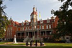
The George M. Cannon House, built in 1890, is an historic Late Victorian mansion located at 720 East Ashton Avenue (2340 South) in the Forest Dale area of Salt Lake City, Utah. It was designed by noted Salt Lake architect John A. Headlund for George Mousley Cannon (December 25, 1861 – January 23, 1937), a member of the Cannon family, a prominent Intermountain West political family. In 1889 George M. Cannon had bought Forest Farm from the estate of Brigham Young and created the subdivision of Forest Dale and later the larger town of Forest Dale, which existed from 1902 until 1912, when it was reabsorbed into Salt Lake City. Brigham Young's Forest Farmhouse was moved in 1975 from its location near this house to the This Is The Place Heritage Park for restoration.On July 18, 1983, the George M. Cannon House was added to the National Register of Historic Places (NRHP). It is the only separately listed property in the Forest Dale Historic District, which was added to the NRHP on April 23, 2009.Today the George M. Cannon House is the Parrish Place Bed and Breakfast, so called because each of its guest rooms is named for a different Maxfield Parrish painting. Its current owners are Jeff and Karin Gauvin, whose 2006 quest to purchase the house was featured on HGTV's House Hunters. Reruns of the program have been shown as recently as October 19, 2009.

Excerpt from the Wikipedia article George M. Cannon House (License: CC BY-SA 3.0, Authors, Images).

George M. Cannon House
Lake Street, Salt Lake City

Geographical coordinates (GPS) Address Nearby Places
placeShow on map

Wikipedia: George M. Cannon HouseContinue reading on Wikipedia

Geographical coordinates (GPS)

Latitude Longitude
N 40.719444444444 ° E -111.86972222222 °
placeShow on map

Address

Lake Street 2398
84106 Salt Lake City
Utah, United States
mapOpen on Google Maps

GEORGE M. CANNON HOUSE, SALT LAKE CITY
Share experience

Nearby Places

Forest Dale Historic District

The Forest Dale Historic District is located in the southeastern part of Salt Lake City, Utah and is roughly bounded by 700 East, Interstate 80, Commonwealth Avenue, and 900 East. It includes the "cohesive core" of the Forest Dale Subdivision platted in 1890, as well as the larger Town of Forest Dale, which was incorporated on January 6, 1902, disincorporated in the fall of 1912, and reabsorbed into the city of Salt Lake City. Both the subdivision and town were created by George Mousley Cannon (December 25, 1861–January 23, 1937), a member of the Cannon family, a prominent Intermountain West political family. The land for Forest Dale was originally Forest Farm, which Cannon had bought in 1889 from the estate of Brigham Young. Despite being bordered on 2 sides by major traffic corridors and on a third by a major arterial highway, the district "maintains its historic "inner-ring" suburban quality due to its tree-lined streets, uniform setbacks, and the similarity of scale in the housing stock." Forest Dale Golf Course is just southeast across I-80, and Fairmont Park is just to the east, separating Forest Dale from downtown Sugar House. The S Line (formerly known as Sugar House Streetcar) includes two stops near Forest Dale and Parley's Trail runs along the streetcar line. The streetcar and trail opened in late 2013 and early 2014, respectively. On April 23, 2009, it was added to the National Register of Historic Places (NRHP). One of the most significant buildings in the district is the George M. Cannon House, which is listed separately on the NRHP.

Sugar House Monument

Erected in 1930, the Sugar House Monument has long stood as a testament to the hard work of early Salt Lake pioneers making the valley sustainable. In 1855, city leaders and early Mormon settlers sought to create the first factory in the western United States to process beets into refined sugar. They decided to purchase the machinery needed for a newly invented process to produce sugar from sugar beets. A mill was built in downtown Sugar House to house the machinery. The process was a failure and in the summer of 1855, Brigham Young ordered the mill to shut down. The old sugar mill building was then converted to a paper factory in 1860, then a bucket factory and finally a machine shop for the Utah Central Railroad until 1928. Despite the failed sugar mill, Sugar House prospered as Salt Lake's second downtown thanks to local merchants and a bustling streetcar system. In the 1920s, sculptor Millard F. Malin pitched the idea of erecting a monument in honor of early manufacturing to the Sugar House Business Men's League. The league and the city of Salt Lake jointly funded the $2,000 monument sculpted by Malin and his two fellow artists; Edward Anderson and Lorenzo Young. The monument was completed and dedicated on November 11, 1934. The obelisk stands approximately 200 feet east of the original site of a Mormon Pioneer sugar mill. Malin describes the monument as: a fifty foot shaft topped by a light. Near the top, the shaft blended into two Indian figures in relief, about eight feet tall, representing the passing of the red man. The Indian facing eastward, militant, holds war implements, and the one facing westward, defeated holds a peace pipe. At the foot of the shaft, facing eastward and westward, are two eight foot figures. The female figure facing eastward represents the Salt Lake Valley in all its productiveness... The male figure facing westward, pouring water from an urn over a wheel, represents a mill builder... On the sides of the shaft between the two figures were two bas-reliefs representing, on the north side, the original old sugar mill, and on the south side, a fur-trading scene in Mr. Smoot's old trading post which once occupied that corner. (The latter plaque has never been completed. The one on the north side, representing the old sugar mill, was added to the monument in 1948) The plaque reads "May the spirit of this courageous venture continue to characterize this community". It was listed on the National Register of Historic Places in 2003.