place

Timeline of San Antonio

Commons category link is locally definedDynamic listsHistory of San AntonioTimelines of cities in Texas
Gfp texas san antonio skyscrapers of san antonio

The following is a timeline of the history of the city of San Antonio, Texas, United States.

Excerpt from the Wikipedia article Timeline of San Antonio (License: CC BY-SA 3.0, Authors, Images).

Timeline of San Antonio
South Laredo Street, San Antonio

Geographical coordinates (GPS) Address Nearby Places
placeShow on map

Wikipedia: Timeline of San AntonioContinue reading on Wikipedia

Geographical coordinates (GPS)

Latitude Longitude
N 29.416667 ° E -98.5 °
placeShow on map

Address

South Laredo Street 824
78204 San Antonio
Texas, United States
mapOpen on Google Maps

Gfp texas san antonio skyscrapers of san antonio
Share experience

Nearby Places

Grass Fight

The Grass Fight was a small battle during the Texas Revolution, fought between the Mexican Army and the Texian Army. The battle took place on November 26, 1835, just south of San Antonio de Béxar in the Mexican region of Texas. The Texas Revolution had officially begun on October 2 and by the end of the month the Texians had initiated a siege of Béxar, home of the largest Mexican garrison in the province. Bored with the inactivity, many of the Texian soldiers returned home; a smaller number of adventurers from the United States arrived to replace them. After the Texian Army rejected commander-in-chief Stephen F. Austin's call to launch an assault on Béxar on November 22, Austin resigned from the army. The men elected Edward Burleson their new commander-in-chief. On November 26, Texian scout Deaf Smith brought news of a Mexican pack train, accompanied by 50–100 soldiers, that was on its way to Bexar. The Texian camp was convinced that the pack train carried silver to pay the Mexican garrison and purchase supplies. Burleson ordered Colonel James Bowie to take 45–50 cavalry and intercept the train. An additional 100 infantry followed. On seeing the battle commence, Mexican General Martín Perfecto de Cos sent reinforcements from Bexar. The Texans repulsed several attacks by Mexican soldiers, who finally retreated to Bexar. When the Texians examined the abandoned pack train they discovered that, instead of silver, the mules carried freshly cut grass to feed the Mexican Army horses. Four Texians were injured, and historian Alwyn Barr states that three Mexican soldiers were killed, although Bowie and Burleson initially claimed the number was much higher.

Casa Navarro
Casa Navarro

Casa Navarro is a historic site in San Antonio, Bexar County, in the U.S. state of Texas. The original house complex was the residence of Texas patriot José Antonio Navarro (1795–1871), a rancher, merchant, leading advocate for Tejano rights, and one of only two native-born Texans to sign the Texas Declaration of Independence. Navarro first bought the property, about 1.5 acres, in 1832. The limestone, caliche block, and adobe structures were built c. 1832–1855, and Navarro moved onto the property soon after.The site is situated in the heart of old San Antonio, in what used to be a thriving Tejano neighborhood known as Laredito. The structures were acquired and restored by the San Antonio Conservation Society between 1960 and 1964, and the site was opened to the public in October 1964. The site was designated a Texas State Historic Landmark in 1962, and listed on the National Register of Historic Places in 1972. On January 1, 2008, the house was transferred from the Texas Parks and Wildlife Department to the Texas Historical Commission. It was designated a National Historic Landmark in 2016. Today, visitors can tour Navarro's one-story limestone house — a fine example of early-statehood domestic architecture — read copies of his writing and discuss questions of history with informed staff. There is also a two-story square store and office building, noted for its bold quoins, which anchor the edges of the building's walls. The detached adobe and caliche block kitchen is typical of early Texas architecture with front and rear porches.

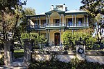
King William Historic District

The King William Historic District of San Antonio, Texas was listed on the National Register of Historic Places listings in Bexar County, Texas on January 20, 1972. The area was originally used as farm acreage by the Spanish priests of the Misión San Antonio de Valero, and eventually parceled off for the local indigenous peoples of the area. In addition to residential homes, the district also includes the King William Park and Bandstand originally built in 1892 on the arsenal grounds, and later moved to its current location. Other features are the Upper Mill Park, the King William River Walk, and the Johnson Street pedestrian bridge.The subdividing of the area into residential lots dates to 1853–66, coincided with the German diaspora in Texas. San Antonio by then was experiencing an influx of German immigrants, fueled in part by the German Adelsverein colonization efforts of the mid-19th century. Wilhelm Thielepape was one of those colonists, and served as Mayor of San Antonio 1867–1872. Surveyor Ernst Hermann Altgelt relocated to San Antonio in 1866, and built the first home in the area now known as the King William District. Being the first home builder in the area, he named it after King of Prussia William I, German Emperor. What eventually became a German enclave of the King William Historic District continued into the next generations. The 419 King William house was built in 1884 by Smith Ellis, but eventually sold to Otto Meusebach, the son of John O. Meusebach who led the Adelsverein colonization and founded the German town of Fredericksburg, Texas.The King William Historic District evolved into more of an area for the financially successful, rather than any particular ethnicity. Louis Bergstrom was a successful businessman from Sweden. Several of the homes were designed by British architect Alfred Giles: the Carl Wilhelm August Groos House, the Edward Steves Homestead; Sartor House for jeweler Alexander Sartor Jr. Giles designed the Oge House for business leader and former Texas Ranger Louis Oge. The area was home to the United States Arsenal beginning in 1859. In 1985, the H-E-Butt grocery chain acquired ten acres for their corporation headquarters.