Moorsholm

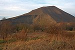
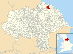
Moorsholm is a village in the unitary authority of Redcar and Cleveland and the ceremonial county of North Yorkshire, England. The village lies 5 miles (8 km) from Saltburn-by-the-Sea between the North York Moors and the North Sea. Because of its proximity to the North Sea coast the area was vulnerable, historically, to attack by invaders from Scandinavia. The name of Moorsholm is of Viking origin with the suffix holm, which meant a settlement, being affixed to the location of the village by the moors: so meaning settlement by the moors. The village used to be called Great Moorsholm to distinguish it from a farm called Little Moorsholm, which is the other side of the Hagg Beck Valley to the north. 'Little Moorsholm' is a title now more commonly applied to a more modern housing estate between that farm and Lingdale. The settlement was mentioned in the Domesday book as Morehusum, belonging to the Earl of Morton and later Clan Bruce, ancestor to the kings of Scotland, and from them descended to the Thwengs, Lumleys, and others. It was a planned mediaeval village built along a main street with crofts and their associated tofts on each side. The church of St Mary, Moorsholm, was built in 1892 and is of stone in 12th-century style. It consists of chancel, nave and west tower.The Memorial Hall was built as a war memorial in 1957 and is used as the doctors’ surgery and meeting room.About 1 mile (1.6 km) to the south of Moorsholm is the landmark of Freebrough Hill, a detached natural hill which is a left over glacial drumlin a relic from the last ice age. This explains its unusual conical shape.
Excerpt from the Wikipedia article Moorsholm (License: CC BY-SA 3.0, Authors, Images).Moorsholm
High Street,
Geographical coordinates (GPS) Address Nearby Places Show on map
Geographical coordinates (GPS)
| Latitude | Longitude |
|---|---|
| N 54.518929 ° | E -0.93627 ° |
Address
High Street
High Street
TS12 3JB , Lockwood
England, United Kingdom
Open on Google Maps


