place

Bear Road, Brighton

Areas of Brighton and HoveRoads in East SussexUse British English from December 2015
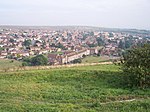
Views of Brighton View towards Bear Road Coombe Road residential area from Hollingbury Fort (August 2013)

The Bear Road area is a largely residential area in the east of Brighton, part of the English city of Brighton and Hove. Centred on the steep west–east road of that name, it is characterised by terraced houses of the early 20th century, but Brighton's main cemeteries were established here in the 19th century and there is also some industry. Bear Road itself, a steeply sloping route running from the main Brighton–Lewes road eastwards towards Brighton Racecourse, divides the area into two contrasting sections. North of the road, the bare hillside was developed with densely populated streets of small houses from 1895 onwards. Development was effectively complete within 20 years, and most of the roads have names connected to the Boer War, giving the suburb "a strong sense of place". Other surviving buildings include some large early-20th-century factories, but an isolation hospital and the area's only church have both been demolished since 1990. South of Bear Road, a series of cemeteries and crematoria were built on a large, undulating area of farmland between 1850 and 1919.

Excerpt from the Wikipedia article Bear Road, Brighton (License: CC BY-SA 3.0, Authors, Images).

Bear Road, Brighton
Bear Road, Brighton Hollingdean

Geographical coordinates (GPS) Address Nearby Places
placeShow on map

Wikipedia: Bear Road, BrightonContinue reading on Wikipedia

Geographical coordinates (GPS)

Latitude Longitude
N 50.837 ° E -0.1146 °
placeShow on map

Address

Bear Road

Bear Road
BN2 4DA Brighton, Hollingdean
England, United Kingdom
mapOpen on Google Maps

Views of Brighton View towards Bear Road Coombe Road residential area from Hollingbury Fort (August 2013)
Share experience

Nearby Places

Brighton Business School

The School of Business and Law is part of the University of Brighton. It offers undergraduate and postgraduate degrees and has about 500 full-time students, 1,000 part-time students and 120 members of academic staff. It provides teaching, research and consultancy in accounting, economics, finance, business, human resources, management, marketing and law. Formerly part of Brighton Technical College, the school has been teaching business and management courses since the 1960s. It is located in Elm House on the Moulsecoomb campus, two kilometers from Brighton city centre. The school runs a number of accredited degrees which lead to some exemptions from professional examinations. Professional bodies affiliated to the school include the Association of Chartered Certified Accountants, the Chartered Institute of Management Accountants, the Chartered Institute of Personnel and Development, the Chartered Institute of Purchasing & Supply, the Chartered Management Institute, the Institute of Chartered Accountants in England and Wales, and The Law Society. The School of Business and Law hosts two research centres: the Centre for Research in Innovation Management (CENTRIM) and the Centre for Research on Management and Employment (CROME). In the latest Research Assessment Exercise (2008), it was ranked as one of the top 15 UK business schools in terms of world-leading research outputs. 70% of the school's business and management research was found to be of international standing or higher.

Whitehawk Camp
Whitehawk Camp

Whitehawk Camp is the remains of a causewayed enclosure on Whitehawk Hill near Brighton, East Sussex, England. Causewayed enclosures are a form of early Neolithic earthwork that were built in England from shortly before 3700 BC until at least 3500 BC, characterized by the full or partial enclosure of an area with ditches that are interrupted by gaps, or causeways. Their purpose is not known; they may have been settlements, or meeting places, or ritual sites. The Whitehawk site consists of four roughly concentric circular ditches, with banks of earth along the interior of the ditches evident in some places. There may have been a timber palisade on top of the banks. Outside the outermost circuit there are at least two more ditches, one of which is thought from radiocarbon evidence to date to the Bronze Age, about two thousand years after the earliest dated activity at the site. Whitehawk was first excavated by R. P. Ross Williamson and E. Cecil Curwen in 1929 in response to a plan to lay out football pitches on the site. Brighton Racecourse overlaps Whitehawk Camp, and when an expansion of the course's pulling-up ground affected part of the site, Curwen led another rescue dig in the winter of 1932–1933; similarly in 1935 the area to be crossed by a new road was excavated, again by Curwen. In 1991, during the construction of a housing development near the site, one of the ditches outside the outermost circuit was uncovered, and the construction was paused to allow an excavation, run by Miles Russell. In 2011, the Gathering Time project published an analysis of radiocarbon dates from almost forty British causewayed enclosures, including several from Whitehawk Camp. The conclusion was that the Neolithic part of the site was probably constructed between 3650 and 3500 BC, and probably went out of use some time between 3500 and 3400 BC. The site was designated as a scheduled monument in 1923.