place

Pontcysyllte Aqueduct
1805 establishments in WalesBridges across the River Dee, WalesBridges by Thomas TelfordBridges completed in 1805Bridges in Wrexham County Borough
Canals in WalesCast iron aqueductsGrade I listed bridges in WalesGrade I listed buildings in Wrexham County BoroughGrade I listed canalsHarv and Sfn no-target errorsLandmarks in WalesLlangollen CanalNavigable aqueducts in WalesPages with Welsh IPATourist attractions in Wrexham County BoroughUse British English from September 2014World Heritage Sites in Wales
Pontcysyllte aqueduct arp

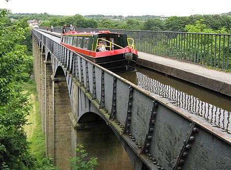
The Pontcysyllte Aqueduct (Welsh pronunciation: [ˌpɔntkəˈsəɬtɛ]; Welsh: Traphont Ddŵr Pontcysyllte) is a navigable aqueduct that carries the Llangollen Canal across the River Dee in the Vale of Llangollen in northeast Wales. The 18-arched stone and cast iron structure is for use by narrowboats and was completed in 1805 having taken ten years to design and build. It is 12 feet (3.7 metres) wide and is the longest aqueduct in Great Britain as well as the highest canal aqueduct in the world. A towpath runs alongside the watercourse on one side.The aqueduct was to have been a key part of the central section of the proposed Ellesmere Canal, an industrial waterway that would have created a commercial link between the River Severn at Shrewsbury and the Port of Liverpool on the River Mersey. Although a less expensive construction course was surveyed further to the east, the westerly high-ground route across the Vale of Llangollen was preferred because it would have taken the canal through the mineral-rich coalfields of North East Wales. Only parts of the canal route were completed because the expected revenues required to complete the entire project were never generated. Most major work ceased after the completion of the Pontcysyllte Aqueduct in 1805. The structure is a Grade I listed building and part of a UNESCO World Heritage Site.

Excerpt from the Wikipedia article Pontcysyllte Aqueduct (License: CC BY-SA 3.0, Authors, Images).

Pontcysyllte Aqueduct
Pontcysyllte Aqueduct,

Geographical coordinates (GPS) Address External links Nearby Places
placeShow on map

Wikipedia: Pontcysyllte AqueductContinue reading on Wikipedia

Geographical coordinates (GPS)

Latitude Longitude
N 52.970555555556 ° E -3.0877777777778 °
placeShow on map

Address

Pontcysyllte Aqueduct

Pontcysyllte Aqueduct
LL20 7TY , Llangollen Rural
Wales, United Kingdom
mapOpen on Google Maps

linkWikiData (Q158822)
linkOpenStreetMap (250823337)

Pontcysyllte aqueduct arp
Share experience

Nearby Places

Acrefair
Acrefair

Acrefair (Welsh: Acre-fair; [ˌakrɛˈvɑɪr] ) is a village in Wrexham County Borough, north-east Wales, in the community of Cefn. It was formerly part of the ancient parish of Ruabon, and is located between Wrexham and Llangollen. It is close to the villages of Trevor, Cefn Mawr, Ruabon and Plas Madoc. The name Acrefair originates from the Welsh word for acres—acrau, or acre in the local Welsh dialect—and Mair, the Welsh name for Mary. The English meaning of Acrefair is Mary's Acres. Parts of Acrefair have views across the River Dee and the Dee Valley. Acrefair has a chemist, kebab shop and two Chinese take-aways and once had a petrol station and newsagents / post office. It boasts many buildings built from "Ruabon Red brick", including several chapels which are now closed and converted.Edward Lloyd Rowland established an ironworks in Acrefair in 1817. Following his bankruptcy in 1825, the works were bought by the British Iron Company. The company was re-formed in 1843 as the New British Iron Company and they continued to operate the works until its closure in 1887. The site was subsequently occupied by a succession of businesses, latterly Air Products, which produced air separation and cryogenic storage equipment. The site ceased commercial operations in late 2009.Acrefair and Cefn Mawr were also home to the Monsanto Company chemical works, which had produced chemicals since before World War II. The site was the American company's first venture in Europe. Monsanto later operated the site as FlexSys, one of their subsidiaries, but production on this site ceased in 2010. Coal, clay and iron were also worked in the area during its industrial period. Acrefair railway station was formerly a station on the Ruabon–Barmouth line, it closed to passengers on 18 January 1965 as part of the Beeching Axe. The Ruabon Brook Tramway passed through the village at street level, serving the Monsanto works and other local industry.