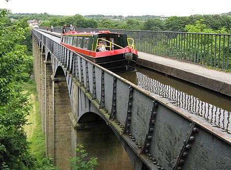
Ellesmere Canal

The Ellesmere Canal was a waterway in England and Wales that was planned to carry boat traffic between the rivers Mersey and Severn. The proposal would create a link between the Port of Liverpool and the mineral industries in north east Wales and the manufacturing centres in the West Midlands. However, the canal was never completed as intended because of its rising costs and failure to generate the expected commercial traffic. The Ellesmere Canal, which was first proposed in 1791, would have created a waterway between Netherpool, Cheshire, and Shrewsbury. However, only certain sections were completed; these were eventually incorporated into the Chester Canal, Montgomery Canal and Shropshire Union Canal. Although several major civil engineering feats were accomplished, major building work ceased following the completion of the Pontcysyllte Aqueduct in 1805. The northern end of the navigation's mainline ended 16 miles (25 km) from Chester at Trevor Basin near Ruabon and its southern end was at Weston Lullingfields about 9 miles (15 km) from Shrewsbury. As part of the rebranding of Britain's industrial waterways as leisure destinations, the surviving central section is now called the Llangollen Canal; even though historically its builders had no intention of sending boat traffic to Llangollen. The branch, from which the waterway now takes its name, was primarily a water feeder from the River Dee above the town. Therefore it was not built as a broad-gauge canal, hence its inherently narrow design.
Excerpt from the Wikipedia article Ellesmere Canal (License: CC BY-SA 3.0, Authors, Images).Ellesmere Canal
Freie Reichsstraße, Wittlich-Land
Geographical coordinates (GPS) Address Nearby Places Show on map
Geographical coordinates (GPS)
| Latitude | Longitude |
|---|---|
| N 53.283333333333 ° | E -2.8833333333333 ° |
Address
Freie Reichsstraße
Freie Reichsstraße
54518 Wittlich-Land
Rheinland-Pfalz, Deutschland
Open on Google Maps


