North Lantau Highway

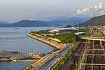
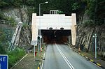
North Lantau Highway is an expressway forming part of Hong Kong's Route 8, linking Hong Kong International Airport and Lantau Island with the rest of the territory. The road has three lanes in each direction for its entire length with full-width hard shoulders for emergencies and breakdowns. The speed limit is 110 kilometres per hour (68 mph) for most of its length, the highest of any road in Hong Kong. North Lantau Highway is 12.5 kilometres (7.8 mi) in length, beginning at Airport Road on Chek Lap Kok. The road then crosses onto Lantau Island and bypasses Tung Chung New Town. The road then travels along the northern coast of Lantau Island, next to the Airport Express and Tung Chung line of the Mass Transit Railway (MTR). This section is built on reclaimed land and through various cuttings. Finally, the road climbs over Ta Shui Wan and Tsing Chau Wan to meet the Lantau Link and its bridges.
Excerpt from the Wikipedia article North Lantau Highway (License: CC BY-SA 3.0, Authors, Images).North Lantau Highway
North Lantau Highway, Islands District Siu Ho Wan
Geographical coordinates (GPS) Address Nearby Places Show on map
 Continue reading on Wikipedia
 Geographical coordinates (GPS)
| Latitude | Longitude |
|---|---|
| N 22.3143 ° | E 113.9924 ° |
Address
北大嶼山公路 North Lantau Highway
North Lantau Highway
Islands District, Siu Ho Wan
Hong Kong, China
Open on Google Maps