place

Monument to Magdeburg Rights (Kyiv)

1800s establishments in UkraineBuildings and structures completed in 1802Culture in KyivLandmarks in KyivMagdeburg rights
Monumental columns in UkraineMonuments and memorials in KyivNational Landmarks in KyivTourist attractions in KyivUkrainian building and structure stubs
Пам'ятник Магдебурзькому праву в Києві (1)

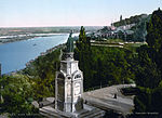
The Monument to the Magdeburg Rights (Ukrainian: Пам'ятник Маґдебурзькому праву) is a monument commemorating the return to Kyiv of its Magdeburg rights, which granted its right to self government. It is located in Podil Raion, Kyiv, at the foothills of the former Mykhailo Hill, next to the Shore Highway. It is considered to be the city's oldest monument. It is also called the Column of the Magdeburg Rights, the Baptizing of Ruthenia Monument, and the Lower Monument of the Saint Volodymyr. It is a scenic spot overlooking the Dnipro river, popular for local baptisms.

Excerpt from the Wikipedia article Monument to Magdeburg Rights (Kyiv) (License: CC BY-SA 3.0, Authors, Images).

Monument to Magdeburg Rights (Kyiv)
Naberezhne Road, Kyiv Клов

Geographical coordinates (GPS) Address External links Nearby Places
placeShow on map

Wikipedia: Monument to Magdeburg Rights (Kyiv)Continue reading on Wikipedia

Geographical coordinates (GPS)

Latitude Longitude
N 50.456008333333 ° E 30.529475 °
placeShow on map

Address

Колона Магдебурзького права

Naberezhne Road
01008 Kyiv, Клов
Ukraine
mapOpen on Google Maps

linkWikiData (Q4228449)
linkOpenStreetMap (3689028523)

Пам'ятник Магдебурзькому праву в Києві (1)
Share experience

Nearby Places

Saint Volodymyr Descent

Saint Volodymyr Descent (Ukrainian: Володимирський узвіз, Volodymyrskyi uzviz) is a street in Kyiv located between the Pechersk and Podil city districts. It stretches from European Square to Postal Square. The city street splits two city parks (Khreshchatyi Park and Saint Volodymyr Hill) located on the slopes of Saint Michael Hill (see Kyiv Mountains). The two parks are connected by the Bridge over Saint Volodymyr Descent, also called the Klitschko Bridge or the Kyiv Glass Bridge, which opened on 25 May 2019.The street started to form in 1711 in place of the so-called Old Pechersk Road that used to connect Pechersk with Podil. As a city street it was known originally as Khreshchatyi Drive (Ukrainian: Хрещатицький приїзд, Khreshchatytskyi pryizd) and later as Paved Street (Ukrainian: Мостова вулиця, Mostova vulytsia) becoming the first city's street paved with cobblestone. Sometime in 1810s it became part of a long Aleksandr Street (after Alexander II of Russia) that stretched all the way from Arsenal Square to Contracts Square, while the descent was unofficially referred to as Aleksandr Descent. After the occupation of Kyiv by the Soviet troops in March 1919 the long street was renamed as Revolution Street (October Revolution). When Kyiv became the capital of the Soviet Ukraine in 1934, the street was renamed once again, now as Sergei Kirov Street after the soviet government official Sergei Kirov. During the Nazi occupation the street along with the modern Hrushevskyi Street carried the name of the Nazi political figure Fritz Todt. During the World War II when Kyiv was freed from Nazi occupation, the former long Kirov Street was split at the Stalin Square (today European Square) into Kirov Street (today Hrushevskyi Street) and Volodymyr Descent that stretched from the Stalin Square to Contracts Square. In 1955 the street was shortened and part of it between Postal Square and Contracts Square was renamed Zhdanov Street (today Sahaidachny Street) after the Soviet official Andrei Zhdanov.