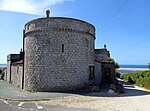
Wyke Regis Training Area

Wyke Regis Training Area is an army training area primarily located in the parish and town of Chickerell, but near to the parish of Wyke Regis in neighbouring Weymouth, Dorset, England. The training area is located at three different sites. It is part of the Ministry of Defence's Defence Training Estate (DTE), which covers 240,000 hectares of land across the country, used to train armed forces. Although mainly used by the army, the training area has allowed an increasing amount of public use of both the climbing facilities and adventure training over the last few years. When the firing range is in use, signs, restriction gates and red flags are used to require walkers to divert inland around the back of the range before returning to the Coastal Path.
Excerpt from the Wikipedia article Wyke Regis Training Area (License: CC BY-SA 3.0, Authors, Images).Wyke Regis Training Area
Camp Road,
Geographical coordinates (GPS) Address Nearby Places Show on map
Geographical coordinates (GPS)
| Latitude | Longitude |
|---|---|
| N 50.5952 ° | E -2.4946 ° |
Address
Camp Road
Camp Road
DT4 9GB , Chickerell
England, United Kingdom
Open on Google Maps


